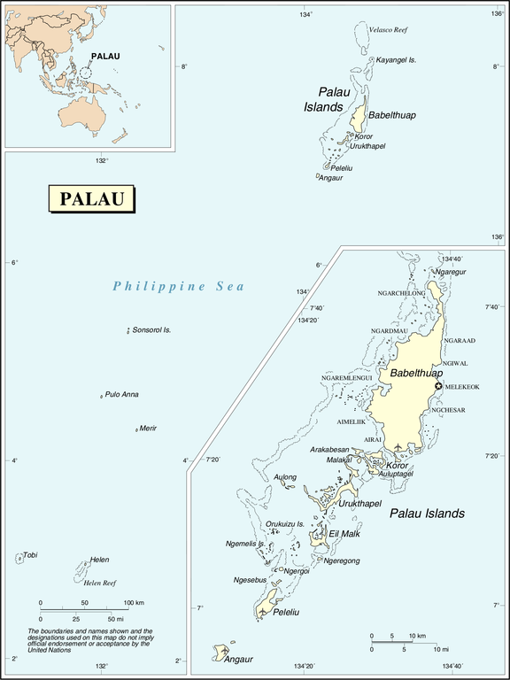
Файл:Un-palau.png

Повна роздільність (1432 × 1909 пікселів, розмір файлу: 357 КБ, MIME-тип: image/png)
| Відомості про цей файл містяться на Вікісховищі — централізованому сховищі вільних файлів мультимедіа для використання у проектах Фонду Вікімедіа. |
| This image is a map derived from a United Nations map.
Unless stated otherwise, UN maps are to be considered in the public domain. This applies worldwide. UN maps are, in principle, open source material and you can use them in your work or for making your own map. UN requests however that you delete the UN name, logo and reference number upon any modification to the map. Content of your map will be your responsibility. You can state in your publication, if you wish, something like: based on UN map … (map name, map number, revision number and date). See: Geospatial Information Section. And: Geospatial, location data for a better world. |
 |
Історія файлу
Клацніть на дату/час, щоб переглянути, як тоді виглядав файл.
| Дата/час | Мініатюра | Розмір об'єкта | Користувач | Коментар | |
|---|---|---|---|---|---|
| поточний | 22:11, 25 жовтня 2007 | | 1432 × 1909 (357 КБ) | Jeroen | Changed the location of the capital to the new capital and fixed the location in the area of the old capital. |
| 01:58, 24 жовтня 2007 |  | 1432 × 1909 (358 КБ) | Jeroen | {{UN map}} Category:Maps of Palau |
Використання файлу
Така сторінка використовує цей файл:
Глобальне використання файлу
Цей файл використовують такі інші вікі:
- Використання в ast.wikipedia.org
- Використання в avk.wikipedia.org
- Використання в en.wikipedia.org
- Використання в fr.wikipedia.org
- Використання в fy.wikipedia.org
- Використання в gom.wikipedia.org
- Використання в km.wikipedia.org
- Використання в nl.wikipedia.org
- Використання в no.wikipedia.org
- Використання в pl.wiktionary.org
- Використання в to.wikipedia.org