Файл:Tropical wet forests.svg

Повна роздільність (SVG-файл, номінально 1052 × 523 пікселів, розмір файлу: 7,7 МБ)
| Відомості про цей файл містяться на Вікісховищі — централізованому сховищі вільних файлів мультимедіа для використання у проектах Фонду Вікімедіа. |
Опис файлу
| Опис |
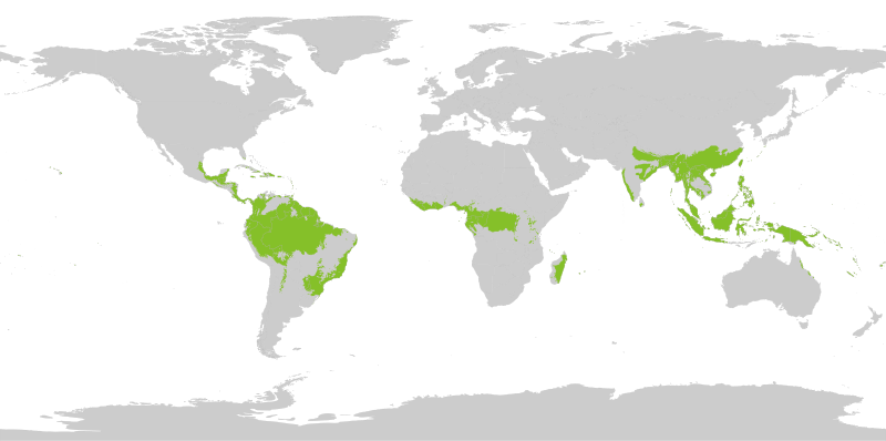
English: Tropical wet forests. The humid tropical biome was delineated using the World Wildlife Fund terrestrial ecoregions map. This map was modified to exclude mountain and coastal forest mosaic ecoregions in Africa.
Français : Forêts tropicales humides. |
| Час створення | |
| Джерело | Власна робота |
| Автор | Yerachmiel C |
Ліцензування
- Ви можете вільно:
- ділитися – копіювати, поширювати і передавати твір
- модифікувати – переробляти твір
- При дотриманні таких умов:
- зазначення авторства – Ви повинні вказати авторство, надати посилання на ліцензію і вказати, чи якісь зміни було внесено до оригінального твору. Ви можете зробити це в будь-який розсудливий спосіб, але так, щоб він жодним чином не натякав на те, наче ліцензіар підтримує Вас чи Ваш спосіб використання твору.
- поширення на тих же умовах – Якщо ви змінюєте, перетворюєте або створюєте іншу похідну роботу на основі цього твору, ви можете поширювати отриманий у результаті твір тільки на умовах такої ж або сумісної ліцензії.
Map uses following sources:
"Biome boundary. The humid tropical biome was delineated using the World Wildlife Fund terrestrial ecoregions map. This map was modified to exclude mountain and coastal forest mosaic ecoregions in Africa." on Global Forest Monitoring Project
Original data licensed as:
"Provided data are available for use for valid scientific, conservation, and educational purposes as long as proper citations are used. We ask that you credit the Humid Tropical Monitoring data as follows: Hansen, M.C., Stehman, S.V., Potapov, P.V., Loveland, T.R., Townshend, J.R.G., DeFries, R.S., Pittman, K.W., Stolle, F., Steininger, M.K., Carroll, M., Dimiceli, C. (2008) Humid tropical forest clearing from 2000 to 2005 quantified using multi-temporal and multi-resolution remotely sensed data. PNAS, 105(27), 9439-9444."
Shapefile of forests:
- By Geographic Information Science Center of Excellence (GIScCE) - SDSU [1] ;
World map with national country outlines and border:
Історія файлу
Клацніть на дату/час, щоб переглянути, як тоді виглядав файл.
| Дата/час | Мініатюра | Розмір об'єкта | Користувач | Коментар | |
|---|---|---|---|---|---|
| поточний | 16:20, 27 серпня 2022 | | 1052 × 523 (7,7 МБ) | Yerachmiel C | reduce stroke around country borders |
| 16:10, 27 серпня 2022 |  | 1052 × 523 (7,76 МБ) | Yerachmiel C | fix | |
| 15:17, 27 серпня 2022 |  | 1052 × 523 (7,9 МБ) | Yerachmiel C | Uploaded own work with UploadWizard |
Використання файлу
Така сторінка використовує цей файл:
Глобальне використання файлу
Цей файл використовують такі інші вікі:
- Використання в en.wikipedia.org
- Використання в en.wikibooks.org
- Використання в he.wikipedia.org