Файл:St Anne, Limehouse (36640179641).jpg

Повна роздільність (2681 × 3648 пікселів, розмір файлу: 5,52 МБ, MIME-тип: image/jpeg)
| Відомості про цей файл містяться на Вікісховищі — централізованому сховищі вільних файлів мультимедіа для використання у проектах Фонду Вікімедіа. |
.jpg)
Опис файлу
| Опис |
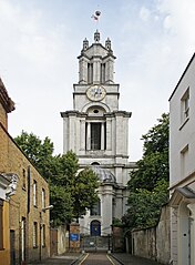
St Anne's Limehouse was formed from part of the parish of St. Dunstan's Stepney, prior to the 18th century a large (but then thinly populated) East London parish that extended all the way down to the Thames River. As the population of London increased, growing parishes were subdivided. In 1709 a new parish in Limehouse was formed from part of the parish of St. Dunstan. The church may be named for Queen Anne as she raised money for it by taxing coal passing along the River Thames. The building was designed by Nicholas Hawksmoor, as one of twelve churches built to serve the needs of the rapidly expanding population of London in the 18th century. The scheme never met its original target, but those built were also known as the Queen Anne Churches. The building was completed in 1727 and consecrated in 1730. Queen Anne decreed that as the new church was close to the river it would be a convenient place of registry for sea captains to register vital events taking place at sea. Therefore, she gave St. Anne's Church the right to display the second most senior ensign of the Royal Navy, the White Ensign. The prominent tower with its golden ball on the flagpole became a Trinity House "sea mark" on navigational charts, and the Queen's Regulations still permit St. Anne's Limehouse to display the White Ensign 24 hours a day, 365 days a year. Hawksmoor, who worked with Wren and Vanburgh, has been 'rediscovered' in recent years. His style is innovative and eclectic. Some have portrayed his churches as centres of gloom and mystery, full of occult and morbid energies and pagan symbols, linked to ancient lay lines and to murders in Whitechapel and on the notorious Ratcliffe Highway (which now links the City and Canary Wharf). |
| Час створення | |
| Джерело | St Anne, Limehouse |
| Автор | Amanda Slater from Coventry, West Midlands, UK |
| Місцеположення камери | | Перегляньте це та інші зображення поблизу на: OpenStreetMap |
|---|
.jpg¶ms=051.510311_N_-000.030169_E_globe:Earth_type:camera_source:Flickr_&language=uk)
Ліцензування
- Ви можете вільно:
- ділитися – копіювати, поширювати і передавати твір
- модифікувати – переробляти твір
- При дотриманні таких умов:
- зазначення авторства – Ви повинні вказати авторство, надати посилання на ліцензію і вказати, чи якісь зміни було внесено до оригінального твору. Ви можете зробити це в будь-який розсудливий спосіб, але так, щоб він жодним чином не натякав на те, наче ліцензіар підтримує Вас чи Ваш спосіб використання твору.
- поширення на тих же умовах – Якщо ви змінюєте, перетворюєте або створюєте іншу похідну роботу на основі цього твору, ви можете поширювати отриманий у результаті твір тільки на умовах такої ж або сумісної ліцензії.
| Це зображення початково було завантажене користувачем amandabhslater на Flickr за посиланням https://flickr.com/photos/15181848@N02/36640179641. 17 листопада 2017 його переглянув робот FlickreviewR 2 і підтвердив, що зображення ліцензоване згідно з умовами cc-by-sa-2.0. |
Історія файлу
Клацніть на дату/час, щоб переглянути, як тоді виглядав файл.
| Дата/час | Мініатюра | Розмір об'єкта | Користувач | Коментар | |
|---|---|---|---|---|---|
| поточний | 08:03, 17 листопада 2017 | | 2681 × 3648 (5,52 МБ) | Ham II | Transferred from Flickr via Flickr2Commons |
Використання файлу
Така сторінка використовує цей файл:
Глобальне використання файлу
Цей файл використовують такі інші вікі:
- Використання в arz.wikipedia.org
- Використання в cs.wikipedia.org
- Використання в de.wikipedia.org
- Використання в de.wikivoyage.org
- Використання в en.wikipedia.org
- Використання в es.wikipedia.org
- Використання в et.wikipedia.org
- Використання в it.wikipedia.org
- Використання в ru.wikipedia.org
- Використання в www.wikidata.org
.jpg)