Файл:Sochi Olympic ski venues NASA.jpg

Повна роздільність (1512 × 1458 пікселів, розмір файлу: 429 КБ, MIME-тип: image/jpeg)
| Відомості про цей файл містяться на Вікісховищі — централізованому сховищі вільних файлів мультимедіа для використання у проектах Фонду Вікімедіа. |
Опис файлу
| ОписSochi Olympic ski venues NASA.jpg |
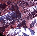
English: Sochi, Russia Winter Olympic Sites (Mountain Cluster)
The 2014 Winter Olympic ski runs may be rated double black diamond, but they're not quite as steep as they appear in this image of the skiing and snowboarding sites for the Sochi Winter Olympic Games, acquired on Jan. 4, 2014, by the Advanced Spaceborne Thermal Emission and Reflection Radiometer (ASTER) instrument on NASA's Terra spacecraft. Rosa Khutar ski resort near Sochi, Russia, is in the valley at center, and the runs are visible on the shadowed slopes on the left-hand side of the valley. Height has been exaggerated 1.5 times to bring out topographic details. The games, which begin on Feb. 7 and continue for 17 days, feature six new skiing and boarding events plus the return of the legendary Jamaican bobsled team to the winter games for the first time since 2002. In this southwest-looking image, red indicates vegetation, white is snow, and the resort site appears in gray. The area imaged is about 11 miles (18 kilometers) across in the foreground and 20 miles (32 kilometers) from front to back. The image was created from the ASTER visible and near-infrared bands, draped over ASTER-derived digital elevation data. With its 14 spectral bands from the visible to the thermal infrared wavelength region and its high spatial resolution of 15 to 90 meters (about 50 to 300 feet), ASTER images Earth to map and monitor the changing surface of our planet. ASTER is one of five Earth-observing instruments launched Dec. 18, 1999, on Terra. The instrument was built by Japan's Ministry of Economy, Trade and Industry. A joint U.S./Japan science team is responsible for validation and calibration of the instrument and data products. The broad spectral coverage and high spectral resolution of ASTER provides scientists in numerous disciplines with critical information for surface mapping and monitoring of dynamic conditions and temporal change. Example applications are: monitoring glacial advances and retreats; monitoring potentially active volcanoes; identifying crop stress; determining cloud morphology and physical properties; wetlands evaluation; thermal pollution monitoring; coral reef degradation; surface temperature mapping of soils and geology; and measuring surface heat balance. The U.S. science team is located at NASA's Jet Propulsion Laboratory, Pasadena, Calif. The Terra mission is part of NASA's Science Mission Directorate, Washington, D.C.Русский: Вид на долину реки Мзымта и Красную Поляну из космоса. Снимок сделан 4 января 2014 года.
Снимок ориентирован с северо-востока (ближе к востоку) на юго-запад (ближе к западу). Снимок охватывает территорию шириной 18 км и в длину 32 км. Расположение объектов на снимке снизу вверх: В нижней части снимка чуть выше заснеженных гор массива Псеашхо виден хребет Псехако, на котором расположен лыжно-биатлонный комплекс. Вправо с хребта идут горнолыжные трассы комплекса Газпром. Расположенные в левой части заснеженные горы - хребет Аибга, на северных склонах которого расположены горнолыжные трассы и экстрим-парк Роза Хутор. В правой части снимка, ближе к верху, заснеженные горы - массив горы Ачишхо. Между Ачишхо и хребтом Аибга в долине расположены посёлок Красная Поляна и Эсто-Садок. |
| Час створення | |
| Джерело | NASA http://www.jpl.nasa.gov/spaceimages/details.php?id=PIA17971 |
| Автор | (ASTER) instrument on NASA's Terra spacecraft |
Ліцензування
| Public domainPublic domainfalsefalse |
| Цей файл перебуває у суспільному надбанні, оскільки він був створений NASA (Національним управлінням з аеронавтики і дослідження космічного простору). Згідно з політикою NASA стосовно авторського права, «матеріали NASA не захищаються авторським правом, якщо не вказано протилежне». (Див. Template:PD-USGov, сторінку політики NASA стосовно авторського права, або політику використання зображень JPL.) |  | |
 |
Попередження:
|
| Анотації InfoField | Це зображення має анотації: Переглянути анотації на Вікісховищі |
Rosa Khutor ski slopes
Laura Biathlon & Ski Complex
Krasnaya Polyana
Esto-Sadok
Rosa Khutor ski area
Gornaya Karusel
Mount Achishkho
Pseashkho Mountains
Rosa Khutor Extreme Park
Gorki Gorod 960
RusSki Gorki Jumping Center
Sliding Center Sanki
Alpica Service ski area
Gazprom Mountain Resort
Підписи
Об'єкти, показані на цьому файлі
зображує
4 січня 2014
image/jpeg
Історія файлу
Клацніть на дату/час, щоб переглянути, як тоді виглядав файл.
| Дата/час | Мініатюра | Розмір об'єкта | Користувач | Коментар | |
|---|---|---|---|---|---|
| поточний | 02:58, 13 лютого 2014 |  | 1512 × 1458 (429 КБ) | Oaktree b | User created page with UploadWizard |
Використання файлу
Така сторінка використовує цей файл:
Глобальне використання файлу
Цей файл використовують такі інші вікі:
- Використання в en.wikipedia.org
- Використання в ru.wikipedia.org