Файл:Pia19039 some key places in a survey of the "Pahrump Hills" .jpg

Повна роздільність (4067 × 2184 пікселів, розмір файлу: 2,27 МБ, MIME-тип: image/jpeg)
| Відомості про цей файл містяться на Вікісховищі — централізованому сховищі вільних файлів мультимедіа для використання у проектах Фонду Вікімедіа. |
Опис файлу
| Опис |
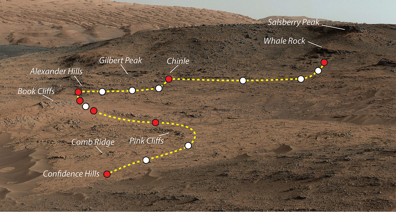
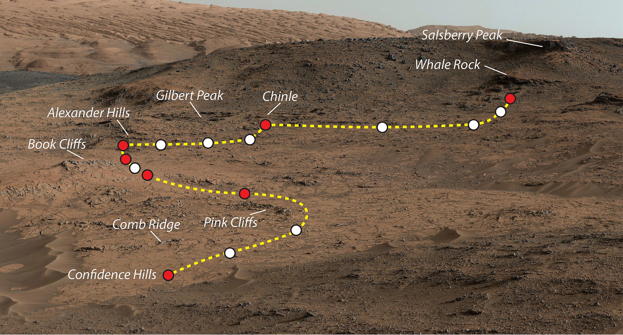
Mars Rover Curiosity's Walkabout at 'Pahrump Hills'. This view shows the path and some key places in a survey of the "Pahrump Hills" outcrop by NASA's Curiosity Mars rover in autumn of 2014. The outcrop is at the base of Mount Sharp within Gale Crater. This view shows the path and some key places in a survey of the "Pahrump Hills" outcrop by NASA's Curiosity Mars rover in autumn of 2014. The outcrop is at the base of Mount Sharp within Gale Crater. The mission's in-place investigation of the layered mountain began at the low edge of the Pahrump Hills outcrop, at the target "Confidence Hills." Curiosity collected a drilled sample of rock powder at that target in September 2014 and delivered portions of the powder into analytical instruments inside the rover. Then the mission began a "walkabout" of the outcrop, similar to the way field geologists on Earth walk across an outcrop to choose the best places on it to examine in detail. The dashed gold line indicates the path the rover drove during the walkabout. Names are shown for a few of the features visited and observed by the rover. Red dots indicate stops at the end of a day's drive. White dots indicate locations of stops made during the drives to collect observations of the Pahrump Hills outcrop. The mission completed the walkabout at the site labeled "Whale Rock", and the team is now examining the observations acquired during the walkabout to decide where to return for more detailed analysis. This view of the outcrop and other portions of Mount Sharp beyond is a mosaic of images taken by the rover's Mast Camera (Mastcam). A larger version of the mosaic is at http://mars.nasa.gov/multimedia/images/?ImageID=6614. NASA's Jet Propulsion Laboratory, a division of the California Institute of Technology, Pasadena, manages the Mars Science Laboratory Project for NASA's Science Mission Directorate, Washington. JPL designed and built the project's Curiosity rover. Malin Space Science Systems, San Diego, built and operates the rover's Mastcam. More information about Curiosity is online at |
| Час створення | |
| Джерело | http://www.nasa.gov/sites/default/files/thumbnails/image/pia19039.jpg |
| Автор | NASA/JPL-Caltech/MSSS |
| Ліцензія (Повторне використання цього файлу) |
NASA |
Ліцензування
| Цей файл перебуває у суспільному надбанні, оскільки він був створений NASA (Національним управлінням з аеронавтики і дослідження космічного простору). Згідно з політикою NASA стосовно авторського права, «матеріали NASA не захищаються авторським правом, якщо не вказано протилежне». (Див. Template:PD-USGov, сторінку політики NASA стосовно авторського права, або політику використання зображень JPL.) | ||
 |
Попередження:
|
Історія файлу
Клацніть на дату/час, щоб переглянути, як тоді виглядав файл.
| Дата/час | Мініатюра | Розмір об'єкта | Користувач | Коментар | |
|---|---|---|---|---|---|
| поточний | 23:49, 4 листопада 2014 | | 4067 × 2184 (2,27 МБ) | Romkur | {{Information |Description=This view shows the path and some key places in a survey of the "Pahrump Hills" outcrop by NASA's Curiosity Mars rover in autumn of 2014. The outcrop is at the base of Mount Sharp within Gale Crater. Image Credit: NASA/JPL-C... |
Використання файлу
Така сторінка використовує цей файл:
Глобальне використання файлу
Цей файл використовують такі інші вікі:
- Використання в en.wikipedia.org
- Використання в pl.wikipedia.org
- Використання в tr.wikipedia.org
- Використання в zh.wikipedia.org