Файл:PIA05484 modest.jpg
Повна роздільність (1278 × 352 пікселів, розмір файлу: 40 КБ, MIME-тип: image/jpeg)
| Відомості про цей файл містяться на Вікісховищі — централізованому сховищі вільних файлів мультимедіа для використання у проектах Фонду Вікімедіа. |
Опис файлу
| Опис |
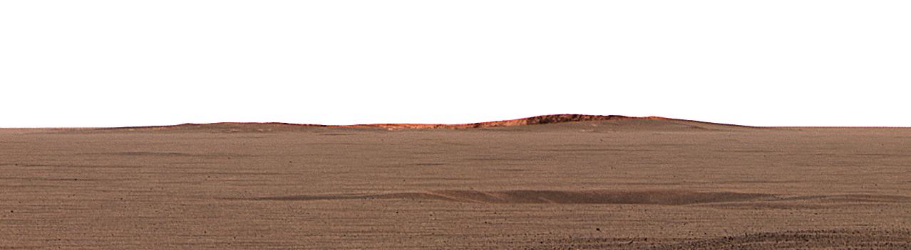
English: This image taken by the Mars Exploration Rover Opportunity's panoramic camera shows the eastern plains that stretch beyond the small crater where the rover landed. In the distance, the rim of a larger crater dubbed "Endurance" can be seen.
This color mosaic was taken on the 32nd martian day, or sol, of the rover's mission and spans 20 degrees of the horizon. It was taken while Opportunity was parked at the north end of the outcrop, in front of the rock region dubbed "El Capitan" and facing east. The features seen at the horizon are the near and far rims of "Endurance," the largest crater within about 6 kilometers (4 miles) of the lander. Using orbital data from the Mars Orbiter Camera on NASA's Mars Global Surveyor spacecraft, scientists estimated the crater to be 160 meters (175 yards) in diameter, and about 720 meters (half a mile) away from the lander. The highest point visible on "Endurance" is the highest point on the far wall of the crater; the sun is illuminating the inside of the far wall. Between the location where the image was taken at "El Capitan" and "Endurance" are the flat, smooth Meridiani plains, which scientists believe are blanketed in the iron-bearing mineral called hematite. The dark horizontal feature near the bottom of the picture is a small, five-meter (16-feet) crater, only 50 meters (164 feet) from Opportunity's present position. When the rover leaves the crater some 2 to 3 weeks from now, "Endurance" is one of several potential destinations. |
| Час створення | |
| Джерело | http://photojournal.jpl.nasa.gov/catalog/PIA05484 |
| Автор | NASA/JPL/Cornell/MSSS |
Це зображення або відео внесене у каталог Лабораторії реактивного руху Національного управління з аеронавтики і дослідження космічного простору США (NASA)під фото ID: PIA05484. Це не тег авторських прав. Дійсна ліцензія має додаватись до цього тегу. Інші мови:
|
Ліцензування
| Цей файл перебуває у суспільному надбанні, оскільки він був створений NASA (Національним управлінням з аеронавтики і дослідження космічного простору). Згідно з політикою NASA стосовно авторського права, «матеріали NASA не захищаються авторським правом, якщо не вказано протилежне». (Див. Template:PD-USGov, сторінку політики NASA стосовно авторського права, або політику використання зображень JPL.) | ||
 |
Попередження:
|
Журнал завантажень локального файлу
- 2004-03-02 23:38 Perl 1100×303× (28911 bytes) This image taken by the Mars Exploration Rover Opportunity's panoramic camera shows the eastern plains that stretch beyond the small crater where the rover landed. In the distance, the rim of a larger crater dubbed "Endurance" can be seen. This color m
Історія файлу
Клацніть на дату/час, щоб переглянути, як тоді виглядав файл.
| Дата/час | Мініатюра | Розмір об'єкта | Користувач | Коментар | |
|---|---|---|---|---|---|
| поточний | 04:53, 17 лютого 2013 | 1278 × 352 (40 КБ) | Huntster | Full size from original source. | |
| 22:51, 28 травня 2009 | 1100 × 303 (28 КБ) | File Upload Bot (Magnus Manske) | {{BotMoveToCommons|en.wikipedia|year={{subst:CURRENTYEAR}}|month={{subst:CURRENTMONTHNAME}}|day={{subst:CURRENTDAY}}}} {{Information |Description={{en|This image taken by the Mars Exploration Rover Opportunity's panoramic camera shows the eastern plains |
Використання файлу
Такі сторінки використовують цей файл:
Глобальне використання файлу
Цей файл використовують такі інші вікі:
- Використання в en.wikipedia.org
- Використання в fa.wikipedia.org
- Використання в fr.wikipedia.org
- Використання в hr.wikipedia.org
- Використання в ja.wikipedia.org
- Використання в no.wikipedia.org
- Використання в ru.wikipedia.org
- Використання в sv.wikipedia.org
- Використання в zh.wikipedia.org