Файл:Osterseen and Isar-Vorlandgletscher Map.jpg

Повна роздільність (6491 × 5355 пікселів, розмір файлу: 24,95 МБ, MIME-тип: image/jpeg)
| Відомості про цей файл містяться на Вікісховищі — централізованому сховищі вільних файлів мультимедіа для використання у проектах Фонду Вікімедіа. |
Опис файлу
| Опис |
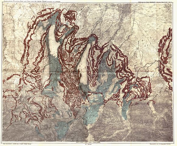
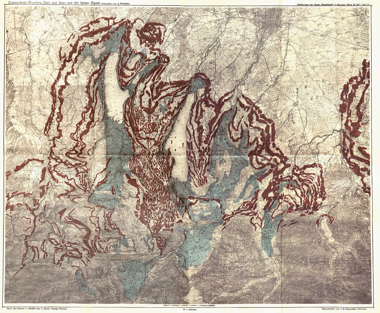
English: Map of the Osterseen Lake area and the prehistoric Isar-Loisach-Glacier in southern Bavaria below the alps, showing the maximum reach of the glacier at the end of the latest ice age, morains and other glacial morphological objects and the glacial lakes appearing from the melting glacier. All lakes are shown in their maximal size despite they did not reach that at the same time, so the state shown on this map did not happen at one single point of time.
Morainswalls (red) and barrier lakes (blue) Deutsch: Karte der Osterseen und des Isar-Vorlandgletschers in Südbayern. Die Karte zeigt rekonstruiert die maximale Ausdehnung des Isar-Loisach-Gletschers am Ende der letzten Eiszeit, Moränen und andere glazialmorphologische Objekte und die ehemaligen Seen, die durch den abschmelzenden Gletscher gebildet wurden. Die Karte zeigt alle Seen in ihrer maximalen Ausdehnung, die nicht gleichzeitig erreicht wurde, so dass der in der Karte dargestellte Zustand so nicht zu einem Zeitpunkt vorhanden war. Würmzeitliche Moränenwälle (rot) und Moränenstauseen (blau) |
|||||
| Час створення | ||||||
| Джерело | August Rothpletz: Die Osterseen und der Isar-Vorlandgletscher. In: Mitteilungen der Geographischen Gesellschaft München. Volume 12, Issue 2 (November 1917) | |||||
| Автор | August Rothpletz (1853-1918) | |||||
| Ліцензія (Повторне використання цього файлу) |
|
|||||

| Анотації | Це зображення має анотації: Переглянути анотації на Вікісховищі |
Історія файлу
Клацніть на дату/час, щоб переглянути, як тоді виглядав файл.
| Дата/час | Мініатюра | Розмір об'єкта | Користувач | Коментар | |
|---|---|---|---|---|---|
| поточний | 09:13, 2 жовтня 2011 | | 6491 × 5355 (24,95 МБ) | Hic et nunc | kleiner Fehler am bildrand |
| 09:10, 2 жовтня 2011 |  | 6491 × 5355 (25,28 МБ) | Hic et nunc | new stitched | |
| 09:47, 29 вересня 2011 |  | 6593 × 5588 (30,44 МБ) | Hic et nunc | {{Information |Description ={{de|1=Karte der Osterseen und des Isar-Vorlandgletschers}} |Source =h-stt Foto |Author =August Rothpletz: Die Osterseen und der Isar-Vorlandgletscher. In: Mitteilungen der Geographischen Gese |
Використання файлу
Така сторінка використовує цей файл:
Глобальне використання файлу
Цей файл використовують такі інші вікі:
- Використання в ca.wikipedia.org
- Використання в de.wikipedia.org
- Використання в fr.wikipedia.org