Файл:Norfolk1880.PNG
Повна роздільність (611 × 700 пікселів, розмір файлу: 1,03 МБ, MIME-тип: image/png)
| Відомості про цей файл містяться на Вікісховищі — централізованому сховищі вільних файлів мультимедіа для використання у проектах Фонду Вікімедіа. |
| Опис |
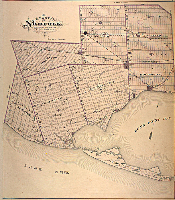
English: This map is originally from the book:
Illustrated historical atlas of the county of Norfolk, Ont. Toronto : H.R. Page & Co., 1877. The map was scanned from this book as part of the McGill University Canadian County Atlas Digital Project. (See: http://digital.library.mcgill.ca/countyatlas/default.htm) I downloaded this image of the map from their project website, specifically: http://digital.library.mcgill.ca/countyatlas/Norfolk.htm
|
| Джерело | |
| Автор |
Ліцензування
This Canadian work is in the public domain in Canada because its copyright has expired due to one of the following:
it was not subject to Crown copyright, and
|
 |
Журнал завантажень локального файлу
- 2006-05-06 06:07 Thirty-seven 611×700× (1075164 bytes) This map is originally from the book: Illustrated historical atlas of the county of Norfolk, Ont. Toronto : H.R. Page & Co., 1877. The map was scanned from this book as part of the [[McGill University]] Canadian County Atlas Digital Project. (See: http:
Історія файлу
Клацніть на дату/час, щоб переглянути, як тоді виглядав файл.
| Дата/час | Мініатюра | Розмір об'єкта | Користувач | Коментар | |
|---|---|---|---|---|---|
| поточний | 15:00, 13 березня 2010 | | 611 × 700 (1,03 МБ) | Fralambert | {{Information |Description={{en|This map is originally from the book: Illustrated historical atlas of the county of Norfolk, Ont. Toronto : H.R. Page & Co., 1877. The map was scanned from this book as part of the en:McGill University Canadian Count |
Використання файлу
Така сторінка використовує цей файл:
Глобальне використання файлу
Цей файл використовують такі інші вікі:
- Використання в en.wikipedia.org
- Використання в es.wikipedia.org
- Використання в fr.wikipedia.org