Файл:Nile River Delta at Night.JPG

Повна роздільність (4256 × 2832 пікселів, розмір файлу: 2,05 МБ, MIME-тип: image/jpeg)
| Відомості про цей файл містяться на Вікісховищі — централізованому сховищі вільних файлів мультимедіа для використання у проектах Фонду Вікімедіа. |
Опис файлу
| Опис |
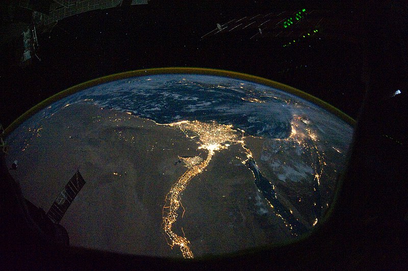
English: In this view of Egypt, we see a population almost completely concentrated along the Nile Valley, just a small percentage of the country’s land area. The Nile River and its delta look like a brilliant, long-stemmed flower in this astronaut photograph of the south-eastern Mediterranean Sea, as seen from the International Space Station. The Cairo metropolitan area forms a particularly bright base of the flower. The smaller cities and towns within the Nile Delta tend to be hard to see amidst the dense agricultural vegetation during the day. However, these settled areas and the connecting roads between them become clearly visible at night. Likewise, urbanized regions and infrastructure along the Nile River becomes apparent.
Another brightly lit region is visible along the eastern coastline of the Mediterranean—the Tel-Aviv metropolitan area in Israel (image right). To the east of Tel-Aviv lies Amman, Jordan. The two major water bodies that define the western and eastern coastlines of the Sinai Peninsula—the Gulf of Suez and the Gulf of Aqaba—are outlined by lights along their coastlines (image lower right). The city lights of Paphos, Limassol, Larnaca, and Nicosia are visible on the island of Cyprus (image top). Scattered blue-grey clouds cover the Mediterranean Sea and the Sinai, while much of north-eastern Africa is cloud-free. A thin yellow-brown band tracing the Earth’s curvature at image top is air-glow, a faint band of light emission that results from the interaction of atmospheric atoms and molecules with solar radiation at approximately 100 kilometres altitude. |
| Час створення | |
| Джерело | NASA Earth Observatory |
| Автор | ISS Expedition 25 crew |
| Інші версії |
Похідні роботи від цього файлу: Nile River Delta at Night cropped.JPG Also see http://earthobservatory.nasa.gov/IOTD/view.php?id=46820&src=eoa-iotd for annotated version, with features identified. |
| Місцеположення камери | | Перегляньте це та інші зображення поблизу на: OpenStreetMap |
|---|
Це зображення або відео внесене у каталог Космічного центру Ліндона Джонсона Національного управління з аеронавтики і дослідження космічного простору США (NASA)під фото ID: ISS025-E-9858. Це не тег авторських прав. Дійсна ліцензія має додаватись до цього тегу. Інші мови:
|
Image acquired with a Nikon D3S digital camera using a 16 mm lens, and is provided by the ISS Crew Earth Observations experiment and Image Science & Analysis Laboratory, Johnson Space Center.
Ліцензування
| Цей файл перебуває у суспільному надбанні, оскільки він був створений NASA (Національним управлінням з аеронавтики і дослідження космічного простору). Згідно з політикою NASA стосовно авторського права, «матеріали NASA не захищаються авторським правом, якщо не вказано протилежне». (Див. Template:PD-USGov, сторінку політики NASA стосовно авторського права, або політику використання зображень JPL.) | ||
 |
Попередження:
|
| Анотації | Це зображення має анотації: Переглянути анотації на Вікісховищі |
Історія файлу
Клацніть на дату/час, щоб переглянути, як тоді виглядав файл.
| Дата/час | Мініатюра | Розмір об'єкта | Користувач | Коментар | |
|---|---|---|---|---|---|
| поточний | 12:51, 8 листопада 2010 | | 4256 × 2832 (2,05 МБ) | Originalwana | {{Information |Description={{en|1=In this view of Egypt, we see a population almost completely concentrated along the Nile Valley, just a small percentage of the country’s land area. The Nile River and its delta look like a brilliant, long-stemmed flow |
Використання файлу
Така сторінка використовує цей файл:
Глобальне використання файлу
Цей файл використовують такі інші вікі:
- Використання в af.wikipedia.org
- Використання в arz.wikipedia.org
- Використання в av.wikipedia.org
- Використання в bg.wikipedia.org
- Використання в bs.wikipedia.org
- Використання в cs.wikipedia.org
- Використання в el.wikipedia.org
- Використання в en.wikipedia.org
- Використання в en.wiktionary.org
- Використання в es.wikipedia.org
- Використання в ha.wikipedia.org
- Використання в he.wikipedia.org
- Використання в incubator.wikimedia.org
- Використання в ln.wikipedia.org
- Використання в ml.wikipedia.org
- Використання в no.wikipedia.org
- Використання в sd.wikipedia.org
- Використання в sk.wikipedia.org
- Використання в sl.wikipedia.org
- Використання в sq.wikipedia.org
- Використання в sq.wikiquote.org
- Використання в sr.wikipedia.org
- Використання в sv.wikipedia.org
- Використання в ta.wikipedia.org
- Використання в th.wikipedia.org
- Використання в tr.wikipedia.org
- Використання в ur.wikipedia.org
- Використання в vi.wikipedia.org