Файл:Map borderline at sea Norway Russia.gif
Розмір при попередньому перегляді: 384 × 599 пікселів. Інші роздільності: 154 × 240 пікселів | 308 × 480 пікселів | 709 × 1106 пікселів.
Повна роздільність (709 × 1106 пікселів, розмір файлу: 265 КБ, MIME-тип: image/gif)
| Відомості про цей файл містяться на Вікісховищі — централізованому сховищі вільних файлів мультимедіа для використання в проектах Фонду Вікімедіа. |
Опис файлу
| Опис |
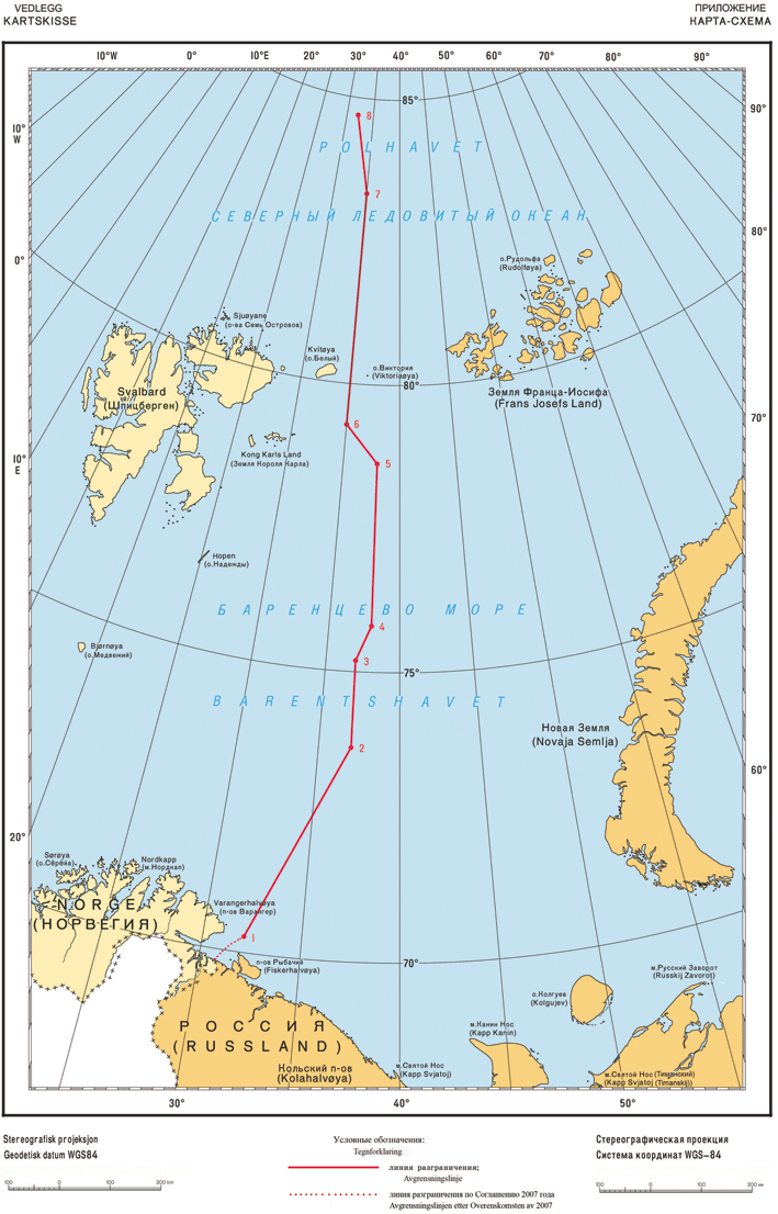
Norsk bokmål: Delelinjen i Barentshavet. |
| Час створення | |
| Джерело | Own work, based upon Norwegian State Departement. |
| Автор | Original uploader wasGryphonis, based upon a work by Norwegian State Departement. |
| Ліцензія (Повторне використання цього файлу) |
Picture is of a document made by the Norwegian State Departement, with a public edict. As such, it's not copyrighted either by Norwegian nor US copyright laws. |
Ліцензування
| This file is in the public domain because legal statutes, administrative regulations, court decisions and other decisions by public authorities are unprotected. This is also the case with proposals, reports and other statements which concern the public exercise of authority, and which are made by a public authority, a publicly appointed council or committee, or published by the public authorities. Similarly, official translations of such texts are unprotected. Intellectual works ("åndsverk" as defined in § 2) which have not been produced specially for use in documents specified in the first paragraph, and from which parts are quoted or which are reproduced in a separate appendix, are not covered by this provision. The same apply to poetry, musical compositions or works of art.
|
 |
Журнал завантажень локального файлу
The original description page is/was here.
Історія файлу
Клацніть на дату/час, щоб переглянути, як тоді виглядав файл.
| Дата/час | Мініатюра | Розмір об'єкта | Користувач | Коментар | |
|---|---|---|---|---|---|
| поточний | 15:57, 8 червня 2011 | | 709 × 1106 (265 КБ) | Gryphonis | {{Information |Description={{no|Delelinjen i Barentshavet.}} |Source=Own work, based upon [http://www.regjeringen.no/upload/UD/Vedlegg/Folkerett/100914_Kartskisse_final.pdf Norwegian State Departement.] |Date=2011-06-08 |Author=[[User: |
Використання файлу
Такі сторінки використовують цей файл:
Глобальне використання файлу
Цей файл використовують такі інші вікі:
- Використання в ca.wikipedia.org
- Використання в cs.wikipedia.org
- Використання в de.wikipedia.org
- Використання в en.wikipedia.org
- Використання в es.wikipedia.org
- Використання в no.wikipedia.org
- Використання в ru.wikipedia.org
- Використання в sv.wikipedia.org
- Використання в vls.wikipedia.org