Файл:Mackenzie river enters Beaufort sea.jpg

Повна роздільність (9000 × 7500 пікселів, розмір файлу: 64 МБ, MIME-тип: image/jpeg)
| Відомості про цей файл містяться на Вікісховищі — централізованому сховищі вільних файлів мультимедіа для використання у проектах Фонду Вікімедіа. |
Опис файлу
| Опис |
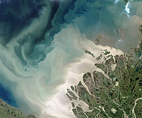
English: The Mackenzie River is the leading source of freshwater flowing into the Arctic Ocean. It's also a leading source of sediment flowing into that basin.
The Operational Land Imager (OLI) on the Landsat 8 satellite acquired this image of the Mackenzie Delta on July 19, 2017. At the time, the Beaufort Sea was colored with milky, tan brush strokes of sediment in various levels of dispersal after pouring out of the river. The Mackenzie is the largest and longest northward-flowing river in North America, and the second largest on the continent (after the Mississippi). The watershed drains a huge, but mostly unsettled portion of Canada; population density along the 4,200 kilometer (2,600 mile) river is just 1 person per square kilometer. About 7 percent of the fresh water that flows into the Arctic Ocean each year comes out the Mackenzie and its delta, and much of that comes in large pulses in June and July after the freshet—when inland ice and snow melts and floods the river. The spring flood carries with it tremendous amounts of dissolved organic material and sediment. More info & refs at source. |
| Час створення | acquired July 19, 2017 |
| Джерело | https://earthobservatory.nasa.gov/IOTD/view.php?id=90703&src=eoa-iotd |
| Автор | NASA Earth Observatory images by Jesse Allen, using Landsat data from the U.S. Geological Survey |
Ліцензування
| Цей файл перебуває у суспільному надбанні, оскільки він був створений NASA (Національним управлінням з аеронавтики і дослідження космічного простору). Згідно з політикою NASA стосовно авторського права, «матеріали NASA не захищаються авторським правом, якщо не вказано протилежне». (Див. Template:PD-USGov, сторінку політики NASA стосовно авторського права, або політику використання зображень JPL.) | ||
 |
Попередження:
|
Історія файлу
Клацніть на дату/час, щоб переглянути, як тоді виглядав файл.
| Дата/час | Мініатюра | Розмір об'єкта | Користувач | Коментар | |
|---|---|---|---|---|---|
| поточний | 07:28, 7 січня 2021 | | 9000 × 7500 (64 МБ) | StellarHalo | higher resolution |
| 05:25, 9 серпня 2017 |  | 720 × 600 (276 КБ) | Tillman | {{Information |Description ={{en|1=The Mackenzie River is the leading source of freshwater flowing into the Arctic Ocean. It's also a leading source of sediment flowing into that basin. The Operational Land Imager (OLI) on the Landsat 8 satellite a... |
Використання файлу
Нема сторінок, що використовують цей файл.
Глобальне використання файлу
Цей файл використовують такі інші вікі:
- Використання в de.wikipedia.org
- Використання в en.wikipedia.org
- Використання в sl.wikipedia.org
- Використання в uz.wikipedia.org