Файл:MGRSgridOriginSchemeAA.png

Розмір при попередньому перегляді: 800 × 553 пікселів. Інші роздільності: 320 × 221 пікселів | 640 × 442 пікселів | 1024 × 707 пікселів | 1280 × 884 пікселів | 1895 × 1309 пікселів.
Повна роздільність (1895 × 1309 пікселів, розмір файлу: 461 КБ, MIME-тип: image/png)
| Відомості про цей файл містяться на Вікісховищі — централізованому сховищі вільних файлів мультимедіа для використання у проектах Фонду Вікімедіа. |
Опис файлу
| Опис |
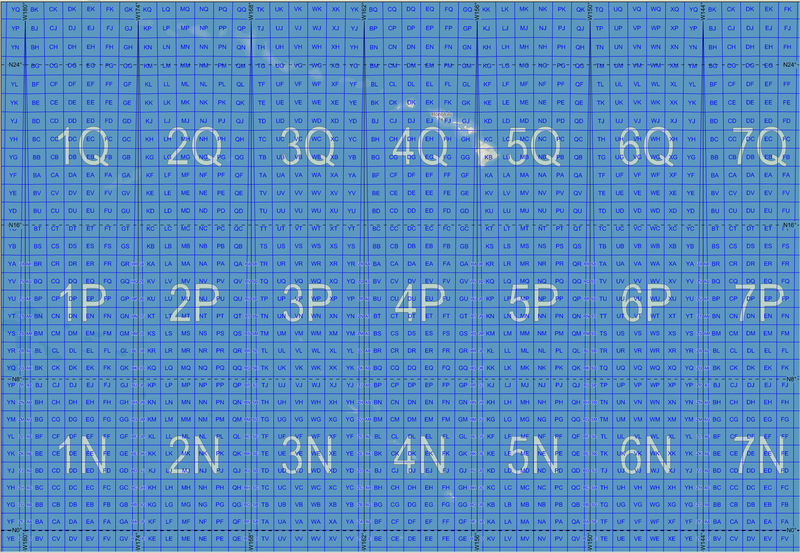
English: Map of the Military Grid Reference System (MGRS) around its origin in the Pacific, with the AA lettering scheme for the 100 km squares. This scheme is used for WGS 84 and some other modern geodetic datums, while the alternative AL lettering scheme is used for some older geodetic datums. |
| Час створення | |
| Джерело |
English: Mikael R made the MGRS grid in Carmenta Engine, with a background map from Natural Earth by Tom Patterson, US National Park Service. |
| Автор | Mikael Rittri (MikaelR) |
Ліцензування
Цей файл ліцензований на умовах ліцензії Creative Commons Attribution-Share Alike 3.0 Unported
- Ви можете вільно:
- ділитися – копіювати, поширювати і передавати твір
- модифікувати – переробляти твір
- При дотриманні таких умов:
- зазначення авторства – Ви повинні вказати авторство, надати посилання на ліцензію і вказати, чи якісь зміни було внесено до оригінального твору. Ви можете зробити це в будь-який розсудливий спосіб, але так, щоб він жодним чином не натякав на те, наче ліцензіар підтримує Вас чи Ваш спосіб використання твору.
- поширення на тих же умовах – Якщо ви змінюєте, перетворюєте або створюєте іншу похідну роботу на основі цього твору, ви можете поширювати отриманий у результаті твір тільки на умовах такої ж або сумісної ліцензії.
Історія файлу
Клацніть на дату/час, щоб переглянути, як тоді виглядав файл.
| Дата/час | Мініатюра | Розмір об'єкта | Користувач | Коментар | |
|---|---|---|---|---|---|
| поточний | 14:49, 20 листопада 2007 | | 1895 × 1309 (461 КБ) | MikaelR | {{Information |Description= {{en|Map of the Military Grid Reference System (MGRS) around its origin in the Pacific, with the AA lettering scheme for the 100 km squares. This scheme is used for WGS 84 and some other modern geodetic datums, while the alter |
| 14:30, 20 листопада 2007 |  | 1895 × 1309 (7,1 МБ) | MikaelR | {{Information |Description= {{en|Map of the Military Grid Reference System (MGRS) around its origin in the Pacific, with the AA lettering scheme for the 100 km squares. This scheme is used for WGS 84 and some other modern geodetic datums, while the alter |
Використання файлу
Така сторінка використовує цей файл:
Глобальне використання файлу
Цей файл використовують такі інші вікі:
- Використання в en.wikipedia.org
- Використання в zh.wikipedia.org