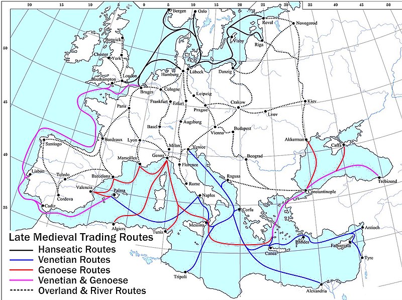
Файл:Late Medieval Trade Routes.jpg

Розмір при попередньому перегляді: 800 × 597 пікселів. Інші роздільності: 320 × 239 пікселів | 640 × 478 пікселів | 1024 × 765 пікселів | 1280 × 956 пікселів | 1457 × 1088 пікселів.
Повна роздільність (1457 × 1088 пікселів, розмір файлу: 372 КБ, MIME-тип: image/jpeg)
Історія файлу
Клацніть на дату/час, щоб переглянути, як тоді виглядав файл.
| Дата/час | Мініатюра | Розмір об'єкта | Користувач | Коментар | |
|---|---|---|---|---|---|
| поточний | 20:46, 18 травня 2022 |  | 1457 × 1088 (372 КБ) | Richard2s | Clearer key for map |
| 20:25, 23 січня 2011 |  | 853 × 544 (453 КБ) | Micsha~commonswiki | Includes map key on the map | |
| 15:55, 28 березня 2008 |  | 1817 × 1120 (487 КБ) | Lampman | {{Information |Description=Map showing the main trade routes of late medieval Europe. The black lines show the routes of the Hanseatic League, the blue Venetian and the red Genoese routes. Purple lines are routes used by both the Venetians and the Genoese |
Використання файлу
Такі сторінки використовують цей файл:
Глобальне використання файлу
Цей файл використовують такі інші вікі:
- Використання в ar.wikipedia.org
- Використання в be-tarask.wikipedia.org
- Використання в bg.wikipedia.org
- Використання в ca.wikipedia.org
- Використання в da.wikipedia.org
- Використання в el.wikipedia.org
- Використання в en.wikipedia.org
- Використання в es.wikipedia.org
- Використання в et.wikipedia.org
- Використання в fr.wikipedia.org
- Використання в he.wikipedia.org
- Використання в hy.wikipedia.org
- Використання в it.wikipedia.org
- Використання в ja.wikipedia.org
- Використання в mk.wikipedia.org
- Використання в nl.wikipedia.org
- Використання в pl.wikipedia.org
- Використання в pt.wikipedia.org
- Використання в rm.wikipedia.org
- Використання в sh.wikipedia.org
- Використання в sl.wikipedia.org
- Використання в sq.wikipedia.org
- Використання в vi.wikipedia.org
- Використання в www.wikidata.org

