Файл:Historic Stevens Trail CA.JPG

Розмір при попередньому перегляді: 800 × 533 пікселів. Інші роздільності: 320 × 213 пікселів | 640 × 427 пікселів | 960 × 640 пікселів.
Повна роздільність (960 × 640 пікселів, розмір файлу: 200 КБ, MIME-тип: image/jpeg)
| Відомості про цей файл містяться на Вікісховищі — централізованому сховищі вільних файлів мультимедіа для використання у проектах Фонду Вікімедіа. |
| Опис |
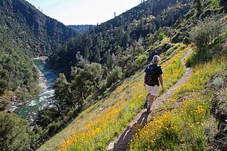
English: The Stevens Trail is a popular year-round hiking trail in the lower elevations of the Sierra Nevada mountain range. Historically, the trail connected the town of Iowa Hill with the city of Colfax, both in Placer County, California.
The current trail extends 4.5 miles along the northwestern slope of the North Fork of the American River Canyon. It begins at the trailhead in Colfax and ends at the confluence of Secret Ravine and the North Fork of the American River. |
|||
| Час створення | Posted March 6, 2013 | |||
| Джерело | https://www.facebook.com/blmcalifornia/photos/a.381118831912797.90344.121009507923732/565469790144366/ | |||
| Автор | CA BLM | |||
| Ліцензія (Повторне використання цього файлу) |
|
Історія файлу
Клацніть на дату/час, щоб переглянути, як тоді виглядав файл.
| Дата/час | Мініатюра | Розмір об'єкта | Користувач | Коментар | |
|---|---|---|---|---|---|
| поточний | 01:07, 30 серпня 2016 | | 960 × 640 (200 КБ) | Tillman | {{Information |Description ={{en|1=The Stevens Trail is a popular year-round hiking trail in the lower elevations of the Sierra Nevada mountain range. Historically, the trail connected the town of Iowa Hill with the city of Colfax, both in Placer Co... |
Використання файлу
Така сторінка використовує цей файл:
Глобальне використання файлу
Цей файл використовують такі інші вікі:
- Використання в azb.wikipedia.org
- Використання в en.wikipedia.org
- Використання в ml.wikipedia.org
- Використання в simple.wikipedia.org
- Використання в ur.wikipedia.org