Файл:Fragments of Larsen B Ice Shelf Lingered Until 2005.gif

Розмір при попередньому перегляді: 600 × 600 пікселів. Інші роздільності: 240 × 240 пікселів | 480 × 480 пікселів | 768 × 768 пікселів | 1024 × 1024 пікселів | 1600 × 1600 пікселів.
Повна роздільність (1600 × 1600 пікселів, розмір файлу: 4,98 МБ, MIME-тип: image/gif, кільцеве, 3 кадри, 6,0с)
| Відомості про цей файл містяться на Вікісховищі — централізованому сховищі вільних файлів мультимедіа для використання у проектах Фонду Вікімедіа. |
Опис файлу
| Опис |
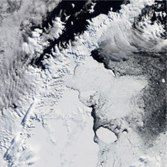
English: The first image was taken one year after the disintegration. Although not frozen solid, the bay is filled with mélange and icebergs, some of them tens of kilometres long. A thin corridor of open ocean, however, lines much of the remaining ice shelf. In the second image, ice continues to fill the bay, and even more ice appears in this image than is visible in the previous shot. Lingering mélange (small chunks of glacier ice and snow, sometimes mixed with sea ice) and icebergs have likely been supplemented by snow and sea ice. The difference between the last image and earlier shots is dramatic. Most of the ice that had lingered in the bay after the Larsen B’s collapse has drifted out to sea, and open ocean predominates. Isolated chunks of ice float on the sea surface far from the remaining edge of the shelf. |
| Час створення | |
| Джерело | NASA Earth Observatory |
| Автор | Jesse Allen and Robert Simmon |
The Moderate Resolution Imaging Spectroradiometer (MODIS) on NASA’s Terra and Aqua satellites captured these images in the years following the collapse.
Ліцензування
| Цей файл перебуває у суспільному надбанні, оскільки він був створений NASA (Національним управлінням з аеронавтики і дослідження космічного простору). Згідно з політикою NASA стосовно авторського права, «матеріали NASA не захищаються авторським правом, якщо не вказано протилежне». (Див. Template:PD-USGov, сторінку політики NASA стосовно авторського права, або політику використання зображень JPL.) | ||
 |
Попередження:
|
Історія файлу
Клацніть на дату/час, щоб переглянути, як тоді виглядав файл.
| Дата/час | Мініатюра | Розмір об'єкта | Користувач | Коментар | |
|---|---|---|---|---|---|
| поточний | 09:17, 9 квітня 2010 | | 1600 × 1600 (4,98 МБ) | Originalwana | {{Information |Description={{en|1=The first image was taken one year after the disintegration. Although not frozen solid, the bay is filled with mélange and icebergs, some of them tens of kilometres long. A thin corridor of open [[:Category:O |
Використання файлу
Така сторінка використовує цей файл:
Глобальне використання файлу
Цей файл використовують такі інші вікі:
- Використання в ast.wikipedia.org
- Використання в en.wikipedia.org
- Використання в es.wikipedia.org
- Використання в fr.wikipedia.org
- Використання в hr.wikipedia.org
- Використання в it.wikipedia.org
- Використання в lv.wikipedia.org
- Використання в nn.wikipedia.org
- Використання в no.wikipedia.org
- Використання в pl.wikipedia.org
- Використання в sh.wikipedia.org
- Використання в zh.wikipedia.org