Файл:Eastern Frontier, Cape of Good Hope, ca 1835.png

Розмір при попередньому перегляді: 684 × 600 пікселів. Інші роздільності: 274 × 240 пікселів | 548 × 480 пікселів | 836 × 733 пікселів.
Повна роздільність (836 × 733 пікселів, розмір файлу: 279 КБ, MIME-тип: image/png)
| Відомості про цей файл містяться на Вікісховищі — централізованому сховищі вільних файлів мультимедіа для використання у проектах Фонду Вікімедіа. |
Опис файлу
| Опис |
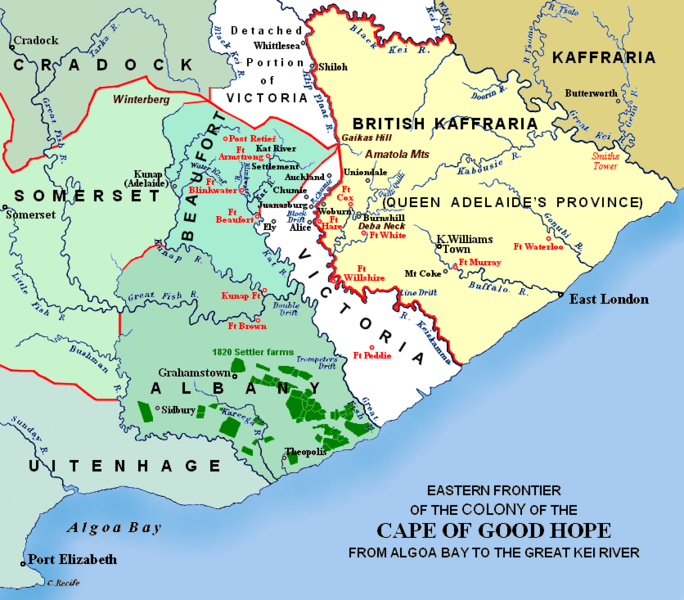
(i.e. period between 5th and 8th Xhosa Wars) 1820 British settler farms in the Albany district, or eastern Zuurveld
Settled colonial area (est. 1795), showing Grahamstown (est. 1812), and districts (est. 1820) in shades of pale green
Neutral zone (est. 1820), as agreed between Lord Charles Somerset and the Gaika (Ngqika) faction of the amaXhosa.
British Kaffraria (est. 1835), incl. East London (est. 1847): Gaika faction of amaXhosa and amaTembu under British protection.
Kaffraria, incl. Butterworth Wesleyan mission (est. 1827): amaTembu living inland and amaXhosa nearer the coast.
Mountains and necks, incl. Gaika's Hill 32°32′46″S 26°57′07″E / 32.54611°S 26.95194°E in the easternmost Winterberg.
Military forts, district boundaries and eastern frontier.
Notes
|
| Час створення | Redrawn and coloured in December 2007 |
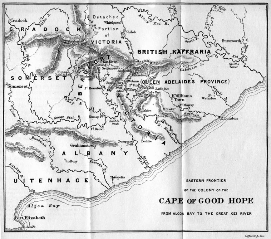
| Джерело | Based on the source map below, last published in 1903. |
| Автор | I created the map, based partly on the source map: Eastern frontier of the Colony of the Cape of Good Hope from Algoa Bay to the Great Kei river, which appears opposite page 620 of ‘The autobiography of Lieutenant-general Sir Harry Smith’ by G.C.B. Bart, Chapter xlviii, published 1903, as part of the online Build a Book initiative. JMK 11:03, 26 December 2007 (UTC) |
| Інші версії |
The original map relates to 1850 more or less, and may be John Arrowsmith's 1851 Eastern Frontier of the Colony of the Cape of Good Hope (and part of Kafirland), From Algoa Bay to the Great Kei River. Arrowsmith's lithograph was redrawn and compiled chiefly from M.S. Surveys & Sketches, communicated by Lt. Col. Mitchell late Survr. Genl. of the Colony and Captn. Wm Owen ...: _(14761876926).jpg) Compare also Arrowsmith, 1836:  |

Ліцензування
Я, власник авторських прав на цей твір, добровільно публікую його на умовах таких ліцензій:

|
Дозволяється копіювати, розповсюджувати та/або модифікувати цей документ на умовах ліцензії GNU FDL версії 1.2 або більш пізньої, виданої Фондом вільного програмного забезпечення, без незмінних розділів, без текстів, які розміщені на першій та останній обкладинці. Копія ліцензії знаходиться у розділі GNU Free Documentation License. |
This file is licensed under the Creative Commons Attribution-Share Alike Attribution-Share Alike 4.0 International, 3.0 Unported, 2.5 Generic, 2.0 Generic and 1.0 Generic license.
- Ви можете вільно:
- ділитися – копіювати, поширювати і передавати твір
- модифікувати – переробляти твір
- При дотриманні таких умов:
- зазначення авторства – Ви повинні вказати авторство, надати посилання на ліцензію і вказати, чи якісь зміни було внесено до оригінального твору. Ви можете зробити це в будь-який розсудливий спосіб, але так, щоб він жодним чином не натякав на те, наче ліцензіар підтримує Вас чи Ваш спосіб використання твору.
- поширення на тих же умовах – Якщо ви змінюєте, перетворюєте або створюєте іншу похідну роботу на основі цього твору, ви можете поширювати отриманий у результаті твір тільки на умовах такої ж або сумісної ліцензії.
Ви можете обрати ліцензію на ваш розсуд.
Історія файлу
Клацніть на дату/час, щоб переглянути, як тоді виглядав файл.
| Дата/час | Мініатюра | Розмір об'єкта | Користувач | Коментар | |
|---|---|---|---|---|---|
| поточний | 00:57, 13 січня 2021 | | 836 × 733 (279 КБ) | JMK | add label |
| 11:41, 13 травня 2019 |  | 836 × 733 (278 КБ) | JMK | Change map colour east of Great Kei River (based on comments received), as it was never part of British Caffraria. Other minor changes. | |
| 11:47, 30 грудня 2007 |  | 836 × 733 (253 КБ) | JMK | Update | |
| 10:58, 26 грудня 2007 |  | 836 × 733 (257 КБ) | JMK | {{Information |Description=Eastern frontier of the Colony of the Cape of Good Hope from Algoa Bay to the Great Kei river *Settled colonial area shown in green, with districts established in 1820 shown in different shades of green *Neutral zone agreed on b | |
| 10:55, 26 грудня 2007 |  | 836 × 733 (257 КБ) | JMK | {{Information |Description=Eastern frontier of the Colony of the Cape of Good Hope from Algoa Bay to the Great Kei river *Settled colonial area shown in green, with districts established in 1820 shown in different shades of green *Neutral zone agreed on b |
Використання файлу
Така сторінка використовує цей файл:
Глобальне використання файлу
Цей файл використовують такі інші вікі:
- Використання в af.wikipedia.org
- Використання в ca.wikipedia.org
- Використання в de.wikipedia.org
- Використання в en.wikipedia.org
- Використання в eo.wikipedia.org
- Використання в es.wikipedia.org
- Використання в fa.wikipedia.org
- Використання в fr.wikipedia.org
- Використання в he.wikipedia.org
- Використання в it.wikipedia.org
- Використання в ja.wikipedia.org
- Використання в mk.wikipedia.org
- Використання в nl.wikipedia.org
- Використання в ru.wikipedia.org
- Використання в sv.wikipedia.org
- Використання в www.wikidata.org
- Використання в xh.wikipedia.org