Файл:Earth-DSCOVR-20150706-IFV.jpg
Повна роздільність (1788 × 1756 пікселів, розмір файлу: 646 КБ, MIME-тип: image/jpeg)
| Відомості про цей файл містяться на Вікісховищі — централізованому сховищі вільних файлів мультимедіа для використання у проектах Фонду Вікімедіа. |
Опис файлу
| Опис |
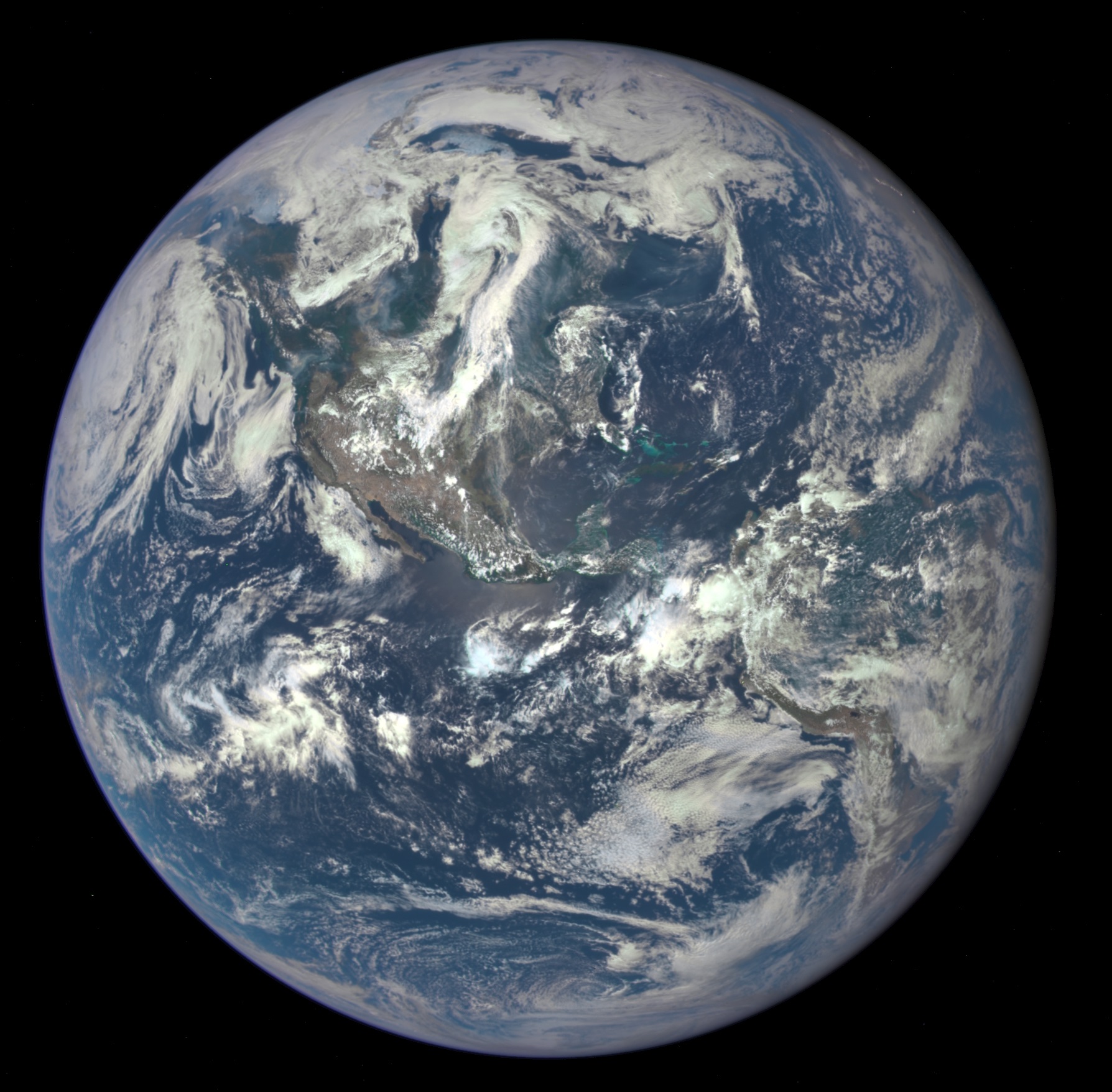
English: NASA Captures "EPIC" Earth Image
A NASA camera on the Deep Space Climate Observatory satellite has returned its first view of the entire sunlit side of Earth from nearly one million miles away. This color image of Earth was taken by NASA’s Earth Polychromatic Imaging Camera (EPIC), a four megapixel CCD camera and telescope. The image was generated by combining three separate images to create a photographic-quality image. The camera takes a series of 10 images using different narrowband filters -- from ultraviolet to near infrared -- to produce a variety of science products. The red, green and blue channel images are used in these color images. The image was taken July 6, 2015, showing North and Central America. The central turquoise areas are shallow seas around the Caribbean islands. This Earth image shows the effects of sunlight scattered by air molecules, giving the image a characteristic bluish tint. The EPIC team is working to remove this atmospheric effect from subsequent images. Once the instrument begins regular data acquisition, EPIC will provide a daily series of Earth images allowing for the first time study of daily variations over the entire globe. These images, available 12 to 36 hours after they are acquired, will be posted to a dedicated web page by September 2015. The primary objective of DSCOVR, a partnership between NASA, the National Oceanic and Atmospheric Administration (NOAA) and the U.S. Air Force, is to maintain the nation’s real-time solar wind monitoring capabilities, which are critical to the accuracy and lead time of space weather alerts and forecasts from NOAA. |
| Час створення | Сфотографовано 6 липня 2015, 19:01:11 |
| Джерело | http://www.nasa.gov/image-feature/nasa-captures-epic-earth-image (image link); see also https://epic.gsfc.nasa.gov/?date=2015-07-06 image #3. |
| Автор | NASA |
| Інші версії |
|


Ліцензування
| Цей файл перебуває у суспільному надбанні, оскільки він був створений NASA (Національним управлінням з аеронавтики і дослідження космічного простору). Згідно з політикою NASA стосовно авторського права, «матеріали NASA не захищаються авторським правом, якщо не вказано протилежне». (Див. Template:PD-USGov, сторінку політики NASA стосовно авторського права, або політику використання зображень JPL.) | ||
 |
Попередження:
|
Історія файлу
Клацніть на дату/час, щоб переглянути, як тоді виглядав файл.
| Дата/час | Мініатюра | Розмір об'єкта | Користувач | Коментар | |
|---|---|---|---|---|---|
| поточний | 11:18, 21 липня 2015 | | 1788 × 1756 (646 КБ) | JorisvS | crop a bit |
| 16:01, 20 липня 2015 |  | 2048 × 2048 (1,49 МБ) | Drbogdan | User created page with UploadWizard |
Використання файлу
Така сторінка використовує цей файл:
Глобальне використання файлу
Цей файл використовують такі інші вікі:
- Використання в ca.wikipedia.org
- Використання в en.wikipedia.org
- Використання в en.wikiquote.org
- Використання в en.wikiversity.org
- Використання в es.wikipedia.org
- Використання в fr.wikipedia.org
- Використання в gl.wikipedia.org
- Використання в he.wikipedia.org
- Використання в incubator.wikimedia.org
- Використання в it.wikipedia.org
- Використання в ja.wikipedia.org
- Використання в pl.wikipedia.org
- Використання в ru.wikipedia.org
- Використання в ru.wiktionary.org
- Використання в tr.wikiquote.org
- Використання в www.wikidata.org
- Використання в wuu.wikipedia.org