Файл:Divalia Fossa IOTD-260.jpg

Повна роздільність (2700 × 1600 пікселів, розмір файлу: 739 КБ, MIME-тип: image/jpeg)
| Відомості про цей файл містяться на Вікісховищі — централізованому сховищі вільних файлів мультимедіа для використання у проектах Фонду Вікімедіа. |
Опис файлу
| Опис |
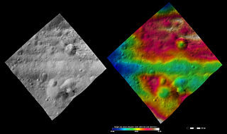
English: Divalia Fossa on 4 Vesta.
Original caption: Apparent brightness and topography images of Divalia Fossa and Rubria and Occia craters The left-hand image is a Dawn FC (framing camera) image, which shows the apparent brightness of Vesta’s surface. The right-hand image is based on this apparent brightness image, which has had a color-coded height representation of the topography overlain onto it. The topography is calculated from a set of images that were observed from different viewing directions, which allows stereo reconstruction. The various colors correspond to the height of the area. The white and red areas in the topography image are the highest areas and the blue areas are the lowest areas. These images show a part of the large trough, Divalia Fossa, which encircles most of Vesta’s equator. Divalia Fossa is visible in both the apparent brightness image and the topography image: it is the approximately 10 kilometer (6 mile) wide depression that runs from the left corner to the right corner of the images. The top rim of Divalia Fossa is especially clear in the topography image. A number of smaller troughs above and below Divalia Fossa are parallel to it. Rubria and Occia craters straddle Divalia Fossa: Rubria is the crater with dark and bright material above Divalia Fossa and Occia is the crater with bright and dark material below. These images are located in Vesta’s Gegania quadrangle, just south of Vesta’s equator. NASA’s Dawn spacecraft obtained the apparent brightness image with its framing camera on Oct. 16, 2011. This image was taken through the camera’s clear filter. The distance to the surface of Vesta is 700 kilometers (435 miles) and the image has a resolution of about 70 meters (230 feet) per pixel. This image was acquired during the HAMO (high-altitude mapping orbit) phase of the mission. These images are lambert-azimuthalmap projected. |
| Час створення | |
| Джерело | http://dawn.jpl.nasa.gov/multimedia/imageoftheday/image.asp?date=20120711 |
| Автор | NASA/ JPL |
Ліцензування
| Цей файл перебуває у суспільному надбанні, оскільки він був створений NASA (Національним управлінням з аеронавтики і дослідження космічного простору). Згідно з політикою NASA стосовно авторського права, «матеріали NASA не захищаються авторським правом, якщо не вказано протилежне». (Див. Template:PD-USGov, сторінку політики NASA стосовно авторського права, або політику використання зображень JPL.) | ||
 |
Попередження:
|
Журнал завантажень локального файлу
| Дата/час | Розмір об'єкта | Користувач | Коментар |
|---|---|---|---|
| 2012-09-15 09:46 | 2700×1600× (756667 bytes) | Kwamikagami | Uploading a public-domain item using [[Wikipedia:File_Upload_Wizard|File Upload Wizard]] |

|
Категорії цього файлу слід перевірити. Перевірте їх зараз!
|
Історія файлу
Клацніть на дату/час, щоб переглянути, як тоді виглядав файл.
| Дата/час | Мініатюра | Розмір об'єкта | Користувач | Коментар | |
|---|---|---|---|---|---|
| поточний | 11:02, 25 листопада 2015 | | 2700 × 1600 (739 КБ) | PlanetUser | Transferred from en.wikipedia |
Використання файлу
Такі сторінки використовують цей файл:
Глобальне використання файлу
Цей файл використовують такі інші вікі:
- Використання в de.wikipedia.org
- Використання в en.wikipedia.org
- Використання в en.wikiversity.org
- Використання в mk.wikipedia.org
- Використання в ro.wikipedia.org
- Використання в ru.wikipedia.org
- Використання в zh.wikipedia.org