Файл:Daedelus comparison, remote sensing in precision farming.jpg
Розмір при попередньому перегляді: 366 × 598 пікселів. Інші роздільності: 147 × 240 пікселів | 540 × 883 пікселів.
Повна роздільність (540 × 883 пікселів, розмір файлу: 143 КБ, MIME-тип: image/jpeg)
| Відомості про цей файл містяться на Вікісховищі — централізованому сховищі вільних файлів мультимедіа для використання у проектах Фонду Вікімедіа. |
| Опис |
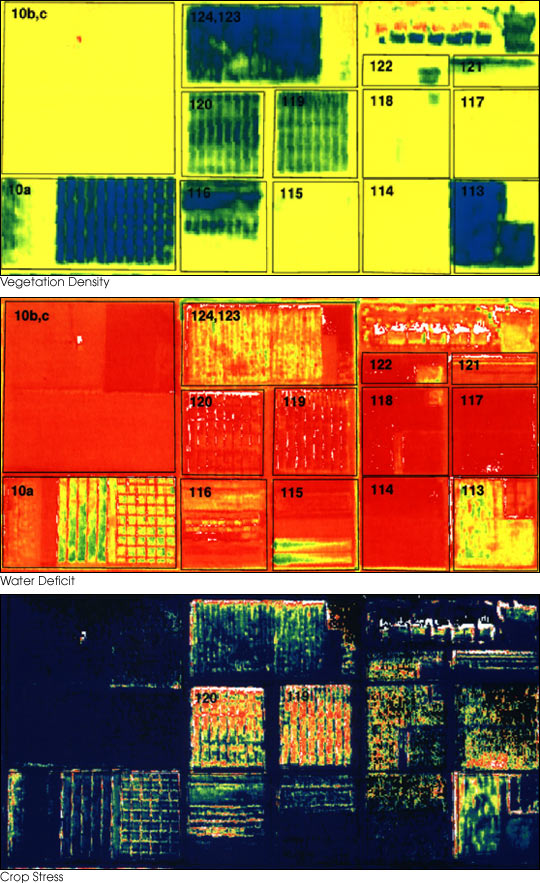
English: These three false-color images demonstrate some of the applications of remote sensing in precision farming. The goal of precision farming is to improve farmers’ profits and harvest yields while reducing the negative impacts of farming on the environment that come from over-application of chemicals. The images were acquired by the Daedalus sensor aboard a NASA aircraft flying over the Maricopa Agricultural Center in Arizona.
|
|||||
| Час створення | до 30 січня 2001 | |||||
| Джерело | earthobservatory.nasa.gov (NASA Earth Observatory, Image of the Day 2001-01-30 "Precision Farming") | |||||
| Автор | Susan Moran, Landsat 7 Science Team and USDA Agricultural Research Service (U.S. Government work) | |||||
| Ліцензія (Повторне використання цього файлу) |
|
|||||
| Інші версії |
.jpg) |

Історія файлу
Клацніть на дату/час, щоб переглянути, як тоді виглядав файл.
| Дата/час | Мініатюра | Розмір об'єкта | Користувач | Коментар | |
|---|---|---|---|---|---|
| поточний | 01:10, 28 червня 2010 | | 540 × 883 (143 КБ) | Bdk | {{Information |Description={{en|These three false-color images demonstrate some of the applications of remote sensing in precision farming. The goal of precision farming is to improve farmers’ profits and harvest yields whi |
Використання файлу
Така сторінка використовує цей файл:
Глобальне використання файлу
Цей файл використовують такі інші вікі:
- Використання в ar.wikipedia.org
- Використання в en.wikipedia.org
- Використання в en.wikiversity.org
- Використання в eu.wikipedia.org
- Використання в fr.wikipedia.org
- Використання в id.wikipedia.org
- Використання в it.wikipedia.org
- Використання в ja.wikipedia.org
- Використання в ko.wikipedia.org
- Використання в ms.wikipedia.org
- Використання в oc.wikipedia.org
- Використання в ru.wikipedia.org
- Використання в ta.wikipedia.org
- Використання в tr.wikipedia.org
- Використання в www.wikidata.org