Файл:Cerros colorados res.jpg

Розмір при попередньому перегляді: 600 × 600 пікселів. Інші роздільності: 240 × 240 пікселів | 480 × 480 пікселів | 768 × 768 пікселів | 1024 × 1024 пікселів | 2048 × 2048 пікселів | 5237 × 5237 пікселів.
Повна роздільність (5237 × 5237 пікселів, розмір файлу: 8,8 МБ, MIME-тип: image/jpeg)
| Відомості про цей файл містяться на Вікісховищі — централізованому сховищі вільних файлів мультимедіа для використання у проектах Фонду Вікімедіа. |
Опис файлу
| Опис |
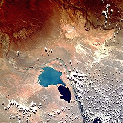
English: Shuttle image of "Cerros Colorados Complex", province of Neuquén, Argentina, March 1990
|
| Час створення | |
| Джерело | http://eol.jsc.nasa.gov/sseop/EFS/photoinfo.pl?PHOTO=STS036-80-62 |
| Автор | Image Science & Analysis Laboratory, NASA Johnson Space Center |
| Місцеположення камери | | Перегляньте це та інші зображення поблизу на: OpenStreetMap |
|---|
Це зображення або відео внесене у каталог Космічного центру Ліндона Джонсона Національного управління з аеронавтики і дослідження космічного простору США (NASA)під фото ID: STS036-80-62. Це не тег авторських прав. Дійсна ліцензія має додаватись до цього тегу. Інші мови:
|
Ліцензування
This file is in the public domain in the United States because it was created by the Image Science & Analysis Laboratory, of the NASA Johnson Space Center. NASA copyright policy states that "NASA material is not protected by copyright unless noted". (NASA media use guidelines or Conditions of Use of Astronaut Photographs).
Photo source: STS036-80-62.
|
Історія файлу
Клацніть на дату/час, щоб переглянути, як тоді виглядав файл.
| Дата/час | Мініатюра | Розмір об'єкта | Користувач | Коментар | |
|---|---|---|---|---|---|
| поточний | 15:38, 7 серпня 2013 | | 5237 × 5237 (8,8 МБ) | Ras67 | high resolution |
| 18:49, 26 жовтня 2007 |  | 640 × 640 (180 КБ) | Denniss | ||
| 20:16, 15 лютого 2007 |  | 600 × 600 (103 КБ) | Rosarinagazo | Shuttle image of "Cerros Colorados Complex", province of Chubut, Argentina Author: NASA http://en.wikipedia.org/wiki/Image:Cerros_colorados_res.jpg Category:Dams |
Використання файлу
Така сторінка використовує цей файл:
Глобальне використання файлу
Цей файл використовують такі інші вікі:
- Використання в de.wikipedia.org
- Використання в en.wikipedia.org
- Використання в eo.wikipedia.org
- Використання в es.wikipedia.org
- Використання в fr.wikipedia.org
- Використання в gl.wikipedia.org
- Використання в lt.wikipedia.org
- Використання в no.wikipedia.org
- Використання в www.wikidata.org
- Використання в zh.wikipedia.org