Файл:Buck Hill Farm Covered Bridge Three Quarters HDR 2950px.jpg

Повна роздільність (2950 × 1930 пікселів, розмір файлу: 3,92 МБ, MIME-тип: image/jpeg)
| Відомості про цей файл містяться на Вікісховищі — централізованому сховищі вільних файлів мультимедіа для використання у проектах Фонду Вікімедіа. |
|
Це зображення місця або будівлі, що занесене до Національного реєстру історичних місць Сполучених Штатів Америки. Його номер у списку 80003528. |
| Місцеположення камери | | Перегляньте це та інші зображення поблизу на: OpenStreetMap |
|---|
| Опис |
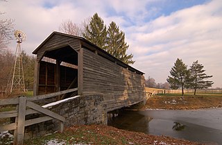
A three-quarters view photograph of the Buck Hill Farm Covered Bridge. The bridge is located in Lancaster County, Pennsylvania. Special thanks to the private owners of this bridge who gave permission for this photo to be taken.
|
||||||
| Час створення | |||||||
| Джерело | Сфотографовано власноруч | ||||||
| Автор | Photo by and (c)2007 Derek Ramsey (Ram-Man) | ||||||
| Ліцензія (Повторне використання цього файлу) |
You may NOT use this image on your own web site or anywhere else unless you release this image and any derivative works (which may include the web page or other medium where this image is used, if it is not considered a "collective work") by following the terms of the following license. Any other use will be considered a breach of copyright law. Please do not copy this image illegally by ignoring the terms of the license, as it is not in the public domain. If you would like special permission to use, license, or purchase the image or prints of the image, or for use in any other fashion or would simply like a copy of the original file, please contact me or email me first to ask. Please see the non-legalese usage guide for more information. Note: While you are not required to do so by the license, please consider letting me know when you reuse one of my photograph images, as a courtesy. Я, власник авторських прав на цей твір, добровільно публікую його на умовах такої ліцензії:
|
||||||

Історія файлу
Клацніть на дату/час, щоб переглянути, як тоді виглядав файл.
| Дата/час | Мініатюра | Розмір об'єкта | Користувач | Коментар | |
|---|---|---|---|---|---|
| поточний | 02:55, 10 грудня 2007 | | 2950 × 1930 (3,92 МБ) | Ram-Man | {{Information |Description=A three-quarters view photograph of the Buck Hill Farm Covered Bridge. The bridge is located in Lancaster County, Pennsylvania. Special thanks to the |
Використання файлу
Така сторінка використовує цей файл:
Глобальне використання файлу
Цей файл використовують такі інші вікі:
- Використання в en.wikipedia.org
- Warwick Township, Lancaster County, Pennsylvania
- List of covered bridges in Lancaster County, Pennsylvania
- National Register of Historic Places listings in Lancaster County, Pennsylvania
- Buck Hill Farm Covered Bridge
- List of covered bridges on the National Register of Historic Places in Pennsylvania
- Використання в es.wikipedia.org
- Використання в fr.wikipedia.org
- Використання в sv.wikipedia.org
- Використання в vi.wikipedia.org
- Використання в www.wikidata.org