Файл:Tunis wetlands ESA389652.jpg

Повна роздільність (5904 × 5364 пікселів, розмір файлу: 50,57 МБ, MIME-тип: image/jpeg)
| Відомості про цей файл містяться на Вікісховищі — централізованому сховищі вільних файлів мультимедіа для використання у проектах Фонду Вікімедіа. |
Опис файлу
| Опис |
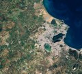
English: This Copernicus Sentinel-2 image features Tunisia’s capital Tunis, in North Africa, and highlights some of the country’s important wetlands.
Captured on 15 December 2017, the image shows part of the Mediterranean’s Gulf of Tunis, which provides natural protection for this ancient city and busy port. The area has seen a series of settlements over the last 3000 years, but arguably the most famous is Carthage, which now forms a suburb to the northeast of the centre of Tunis. While the image offers sharp contrast between the city’s urban environment and surrounding hills and agricultural fields, it also depicts several bodies of water, which are protected under theRamsar Convention on Wetlands. World Wetlands Day is celebrated every year on 2 February, and with this year’s theme being Wetlands for a Sustainable Urban Future, this image of Tunis highlights how important these wetlands are to the city. There are seven Ramsar sites around Tunis, five of which are visible in the image. Lake Tunis can be seen close to the coast and features a causeway. It is a brackish lagoon surrounded by intertidal marshes. It offers good nesting grounds for several species of bird and wintering grounds for species such as the Greater Flamingo. Mammals include rodents and bats, and it is an important source of food, a spawning ground and a nursery for several fish species. The main human activity carried out is fishing, regulated according to its protected status. The shallow lake of Sebkhet Sejoumi is west of Lake Tunis and is one of the largest water reservoirs protecting the capital from floods. Unlike other sebkhets – or salt lakes – in the area, Sejoumi retains some water all year and is therefore particularly important for wildlife in the summer when other sebkhets dry up. The smaller protected lakes of Ghdir El Golla and Barrage Mornaguia can be seen further west on the outskirts of the city. To the north of the city, lies Sebkhet Ariana which loses much of its water in the summer. Through itsGlobWetland Africaproject, ESA works in partnership with the Ramsar Secretariat to use information from satellites to help conserve and manage vulnerable wetlands such as these. This image is featured on theEarth from Space video programme.Українська: Супутниковий знімок міста Туніс, столиці однойменної північноафриканської держави. Знімок зроблений супутником Сентінел-2 (Sentinel-2) за програмою Копернік (Copernicus) Європейської космічної агенції (ESA) 15 грудня 2017 року.
На півночі видно частину Туніської затоки Середземного моря, на березі якого 3000 років тому було збудоване стародавнє місто Карфаген (на північному сході міста) та діє сучасний морський порт. На зображенні видно різкий контраст між селітебними землями та сільськогосподарськими угіддями. Також можна розрізнити 5 з 7 водойм навколо Туніса, які охороняються в рамках Рамсарської конвенції про водно-болотні угіддя і є важливою частиною природної екосистеми туніської столиці. Всесвітній день водно-болотних угідь відзначається щорічно 2 лютого. Озеро Туніс — солона лагуна оточена заболоченою місцевістю поруч з узбережжям. Це місце гніздування для декількох видів птахів та зимівлі рожевого фламінго. На озері велика кількість гризунів і кажанів. Озеро використовується в якості розплідника для кількох видів риб. Основною діяльністю людини на озері є рибальство, яке регулюється відповідно з його охоронним статусом. Неглибоке озеро Себха-Сежумі знаходиться на захід від озера Туніс. Це найбільше водосховище, що захищає столицю від повені. На відміну від інших себх (солоних озер) озеро Сежумі зберігає воду впродовж цілого року, тому особливо важливе для дикої природи влітку, коли інші себхети висихають. Менші озера Гдір-ель-Голла і Барраж-Морнагуя можна побачити на західних околицях міста. На північ від міста лежить Себха-Ар'ана, яке пересихає влітку. Завдяки проекту «Глоуб Ветленд Африка», ЄКА співпрацює з Рамсарським секретаріатом для використання інформації з супутників для допомоги у збереженні й менеджменті вразливими водно-болотними угіддями. Це зображення було використане у відеоролику програми «Земля з космосу» 2 лютого 2018 року. |
| Час створення | |
| Джерело | http://www.esa.int/spaceinimages/Images/2018/02/Tunis_wetlands |
| Автор | European Space Agency |
| Ліцензія (Повторне використання цього файлу) |
contains modified Copernicus Sentinel data (2017), processed by ESA,CC BY-SA 3.0 IGO |
| Інші версії |
|
| Title | Tunis wetlands |
| System | Copernicus |
| Set | Earth observation image of the week |
| Mission | Sentinel-2 |
| Activity | Observing the Earth |
Ліцензування
- Ви можете вільно:
- ділитися – копіювати, поширювати і передавати твір
- модифікувати – переробляти твір
- При дотриманні таких умов:
- зазначення авторства – Ви повинні вказати авторство, надати посилання на ліцензію і вказати, чи якісь зміни було внесено до оригінального твору. Ви можете зробити це в будь-який розсудливий спосіб, але так, щоб він жодним чином не натякав на те, наче ліцензіар підтримує Вас чи Ваш спосіб використання твору.
- поширення на тих же умовах – Якщо ви змінюєте, перетворюєте або створюєте іншу похідну роботу на основі цього твору, ви можете поширювати отриманий у результаті твір тільки на умовах такої ж або сумісної ліцензії.

|
This image contains data from a satellite in the Copernicus Programme, such as Sentinel-1, Sentinel-2 or Sentinel-3. Attribution is required when using this image.
Зазначення авторства: Contains modified Copernicus Sentinel data {{{year}}}
The use of Copernicus Sentinel Data is regulated under EU law (Commission Delegated Regulation (EU) No 1159/2013 and Regulation (EU) No 377/2014). Relevant excerpts:
Free access shall be given to GMES dedicated data [...] made available through GMES dissemination platforms [...].
Access to GMES dedicated data [...] shall be given for the purpose of the following use in so far as it is lawful:
GMES dedicated data [...] may be used worldwide without limitations in time.
GMES dedicated data and GMES service information are provided to users without any express or implied warranty, including as regards quality and suitability for any purpose. |
Історія файлу
Клацніть на дату/час, щоб переглянути, як тоді виглядав файл.
| Дата/час | Мініатюра | Розмір об'єкта | Користувач | Коментар | |
|---|---|---|---|---|---|
| поточний | 02:59, 8 лютого 2021 | | 5904 × 5364 (50,57 МБ) | StellarHalo | higher resolution |
| 16:55, 2 лютого 2018 |  | 2000 × 1817 (2,3 МБ) | Fæ | European Space Agency, Id 389652, http://www.esa.int/spaceinimages/Images/2018/02/Tunis_wetlands, User:Fæ/Project_list/ESA |
Використання файлу
Такі сторінки використовують цей файл: