Файл:Nouvelle-France map-fr.svg

Повна роздільність (SVG-файл, номінально 1530 × 1090 пікселів, розмір файлу: 375 КБ)
| Відомості про цей файл містяться на Вікісховищі — централізованому сховищі вільних файлів мультимедіа для використання у проектах Фонду Вікімедіа. |
Опис файлу
| Опис |
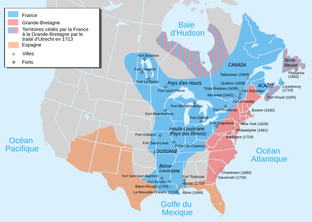
Català: Mapa de la Nova França sobre 1754-1755 English: Map of New France about 1750 using modern political boundaries Español: Mapa de la Nueva Francia cerca de 1750. Français : Carte de la Nouvelle-France vers 1754-1755 Norsk nynorsk: Kart over Ny Frankrike (ca 1754-1755) Русский: Карта Французских колоний в Америке 1750 中文(中国大陆): 1750年左右的新法兰西地图,附现代边界。 العربية : خريطة فرنسا الجديدة حوالي عام 1750 باستخدام الحدود السياسية الحديثة |
||
| Час створення | |||
| Джерело |
travail personnel from Image:Nouvelle-France1750.png 1) Les Villes françaises du Nouveau Monde : des premiers fondateurs aux ingénieurs du roi, XVIe-XVIIIe siècles / sous la direction de Laurent Vidal et Emilie d'Orgeix /Éditeur : Paris : Somogy 1999. 2) Canada-Québec 1534-2000/ Jacques Lacoursière, Jean Provencher et Denis Vaugeois/Éditeur: Sillery (Québec): Septentrion 2000. |
||
| Автор | Pinpin | ||
| Інші версії |
File:Nouvelle-France map-fr.svg has 4 translations.
Other related versions:[]
|


|
Цей SVG-файл містить вкладений текст, який може бути легко перекладений Вашою мовою за допомогою інструменту SVG Translate або будь-якого редактора SVG. Дізнайтесь більше про переклад SVG-файлів. |
Цей файл перекладається за допомогою елементів SVG <switch>. Усі переклади зберігаються в цьому ж файлі! Дізнайтесь більше.
Щоб додати цей файл Вашою мовою (якщо доступно), скористайтесь параметром Щоб перекласти цей файл Вашою мовою, Ви можете скористатися інструментом SVG Translate. Або ж Ви можете завантажити файл на свій комп'ютер, додати свій переклад у зручній для Вас програмі, і завантажте оновлену версію під тією ж назвою. Якщо Ви не впевнені, як це зробити, допомогу зможете знайти у Графічній лабораторії. |
Ліцензування

|
Дозволяється копіювати, розповсюджувати та/або модифікувати цей документ на умовах ліцензії GNU FDL версії 1.2 або більш пізньої, виданої Фондом вільного програмного забезпечення, без незмінних розділів, без текстів, які розміщені на першій та останній обкладинці. Копія ліцензії знаходиться у розділі GNU Free Documentation License. |
- Ви можете вільно:
- ділитися – копіювати, поширювати і передавати твір
- модифікувати – переробляти твір
- При дотриманні таких умов:
- зазначення авторства – Ви повинні вказати авторство, надати посилання на ліцензію і вказати, чи якісь зміни було внесено до оригінального твору. Ви можете зробити це в будь-який розсудливий спосіб, але так, щоб він жодним чином не натякав на те, наче ліцензіар підтримує Вас чи Ваш спосіб використання твору.
- поширення на тих же умовах – Якщо ви змінюєте, перетворюєте або створюєте іншу похідну роботу на основі цього твору, ви можете поширювати отриманий у результаті твір тільки на умовах такої ж або сумісної ліцензії.
Історія файлу
Клацніть на дату/час, щоб переглянути, як тоді виглядав файл.
| Дата/час | Мініатюра | Розмір об'єкта | Користувач | Коментар | |
|---|---|---|---|---|---|
| поточний | 17:12, 18 вересня 2023 | | 1530 × 1090 (375 КБ) | JoanSMF | File uploaded using svgtranslate tool (https://svgtranslate.toolforge.org/). Added translation for ca. |
| 17:09, 18 вересня 2023 |  | 1530 × 1090 (370 КБ) | JoanSMF | File uploaded using svgtranslate tool (https://svgtranslate.toolforge.org/). Added translation for ca. | |
| 19:40, 14 грудня 2022 |  | 1530 × 1090 (366 КБ) | Tcr25 | Fort Rosaile in wrong location; add Fort St-Jean-Baptiste | |
| 02:14, 23 серпня 2021 |  | 1530 × 1090 (353 КБ) | Praça de Maio | File uploaded using svgtranslate tool (https://svgtranslate.toolforge.org/). Added translation for tr. | |
| 02:13, 23 серпня 2021 |  | 1530 × 1090 (351 КБ) | Praça de Maio | File uploaded using svgtranslate tool (https://svgtranslate.toolforge.org/). Added translation for tr. | |
| 11:30, 5 квітня 2020 |  | 1530 × 1090 (343 КБ) | Les Meloures | File uploaded using svgtranslate tool (https://tools.wmflabs.org/svgtranslate/). Added translation for lb. | |
| 11:15, 5 квітня 2020 |  | 1530 × 1090 (343 КБ) | Les Meloures | File uploaded using svgtranslate tool (https://tools.wmflabs.org/svgtranslate/). Added translation for lb. | |
| 12:59, 12 березня 2020 |  | 1530 × 1090 (326 КБ) | Gumruch | Reverted to version as of 11:30, 24 September 2018 (UTC) | |
| 12:58, 12 березня 2020 |  | 1530 × 1090 (342 КБ) | Gumruch | File uploaded using svgtranslate tool (https://tools.wmflabs.org/svgtranslate/). Added translation for cs. | |
| 11:30, 24 вересня 2018 |  | 1530 × 1090 (326 КБ) | GrandCelinien | Reverted to version as of 22:43, 3 December 2011 (UTC) - La carte est toute floue, ce n'est même plus une vraie SVG. |
Використання файлу
Такі сторінки використовують цей файл:
Глобальне використання файлу
Цей файл використовують такі інші вікі:
- Використання в ang.wikipedia.org
- Використання в be-tarask.wikipedia.org
- Використання в be.wikipedia.org
- Використання в bg.wikipedia.org
- Використання в ca.wikipedia.org
- Використання в co.wikipedia.org
- Використання в cs.wikipedia.org
- Використання в de.wikipedia.org
- Використання в el.wikipedia.org
- Використання в eo.wikipedia.org
- Використання в fr.wikipedia.org
- Discussion:Québec/Archive 2
- René-Robert Cavelier de La Salle
- Liste des colonies françaises
- Histoire du Canada
- Pierre André de Suffren
- Traité de Versailles (1783)
- Empire colonial français
- Royaume de France
- Histoire de l'Acadie
- Quelques arpents de neige
- Territoires français du nord
- Guerre de la Conquête
- États-Unis
- Franco-Américains
- Utilisateur:Urban/cartes
- Colonisation française des Amériques
- Utilisateur:Xinpeijin/Aide:Captcha
- Portail:Nouvelle-France/Carte de la Nouvelle-France
- Wikipédia:Atelier graphique/Cartes/Archives/décembre 2007
- Liste des forts de la Nouvelle-France
- Discussion utilisateur:The Ogre
- En canot sur les chemins d'eau du Roi
- Vieilles colonies
- Portail:Nouvelle-France
- Histoire de la Louisiane
- Immigration française à Porto Rico
- Histoire de France
- Ferme d'Occident
- Alliance franco-indienne (Amérique)
- Wikipédia:Atelier graphique/Cartes/Archives/Demandes mises en sommeil/Amériques
- Projet:Nouvelle-France/Brasserie Port-Royal/Archives 8
- Colonisation basque des Amériques
Переглянути сторінку глобального використання цього файлу.