Файл:Northern Mali conflict.svg

Розмір цього попереднього перегляду PNG для вихідного SVG-файлу: 629 × 600 пікселів. Інші роздільності: 252 × 240 пікселів | 503 × 480 пікселів | 805 × 768 пікселів | 1074 × 1024 пікселів | 2148 × 2048 пікселів | 1316 × 1255 пікселів.
Повна роздільність (SVG-файл, номінально 1316 × 1255 пікселів, розмір файлу: 796 КБ)
| Відомості про цей файл містяться на Вікісховищі — централізованому сховищі вільних файлів мультимедіа для використання у проектах Фонду Вікімедіа. |
Опис файлу
| Опис |
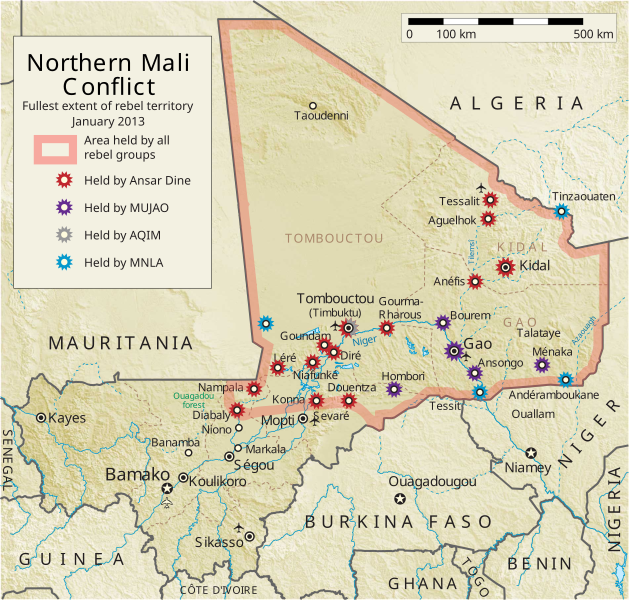
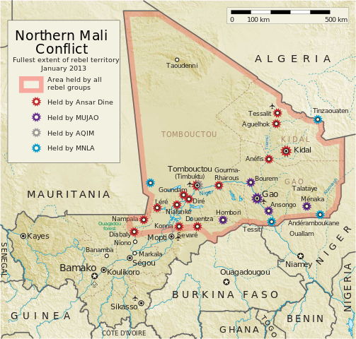
English: Map of the conflict in Northern Mali. (English)
العربية: خريطة الصّراع في شمال مالي. (إنجليزي)
Français : Carte du conflit au nord du Mali. (Anglais)
Latina: Charta rebellionis Tuaregorum in Malia septentrionali. (Anglice)
Українська: Карта конфлікту на півночі Малі. (Англійською) |
| Джерело |
Власна робота This vector image includes elements that have been taken or adapted from this file: This vector image includes elements that have been taken or adapted from this file: |
| Автор | Orionist |
| Інші версії | German/Deutsch/Allemand, French/Français, Macedonian/македонски јазик/Macédonien |
| SVG розвиток | Вихідний код цього SVG-файлу неправильний. Це векторне зображення було створено з допомогою Adobe Illustrator, and with Inkscape. |
Notes
- ↑ US Department of State, "Country Reports on Terrorism 2011", Chapter 2 Country Reports: Africa Overview, 31 July 2012
Ліцензування
Я, власник авторських прав на цей твір, добровільно публікую його на умовах такої ліцензії:
Цей файл ліцензований на умовах Creative Commons Attribution-Share Alike 3.0 Unported
- Ви можете вільно:
- ділитися – копіювати, поширювати і передавати твір
- модифікувати – переробляти твір
- При дотриманні таких умов:
- зазначення авторства – Ви повинні вказати авторство, надати посилання на ліцензію і вказати, чи якісь зміни було внесено до оригінального твору. Ви можете зробити це в будь-який розсудливий спосіб, але так, щоб він жодним чином не натякав на те, наче ліцензіар підтримує Вас чи Ваш спосіб використання твору.
- поширення на тих же умовах – Якщо ви змінюєте, перетворюєте або створюєте іншу похідну роботу на основі цього твору, ви можете поширювати отриманий у результаті твір тільки на умовах такої ж або сумісної ліцензії.
Історія файлу
Клацніть на дату/час, щоб переглянути, як тоді виглядав файл.
| Дата/час | Мініатюра | Розмір об'єкта | Користувач | Коментар | |
|---|---|---|---|---|---|
| поточний | 06:59, 8 квітня 2014 | | 1316 × 1255 (796 КБ) | Ansh666 | Reverted to version as of 16:51, 8 March 2013 - restoring the correct version, as the map is supposed to be historical, not current |
| 20:15, 5 грудня 2013 |  | 1316 × 1255 (699 КБ) | Hanibal911 | more accurately reflects the situation | |
| 16:51, 8 березня 2013 |  | 1316 × 1255 (796 КБ) | Agricolae | Hombori dot restored | |
| 14:29, 5 березня 2013 |  | 1316 × 1255 (794 КБ) | TUFKAAP | Since this is an English map, Al-Qaeda in the Islamic Maghreb should be abbreviated as AQIM. | |
| 03:33, 11 лютого 2013 |  | 1316 × 1255 (794 КБ) | Agricolae | shift text distorted on upload | |
| 03:27, 11 лютого 2013 |  | 1316 × 1255 (794 КБ) | Agricolae | change to show greatest extent - see WP Talk:Northern Mali conflict (2012–present) | |
| 06:36, 8 лютого 2013 |  | 1316 × 1255 (699 КБ) | Rama | Aguelhok contested or taken ( http://www.lemonde.fr/afrique/article/2013/02/08/mali-les-forces-francaise-et-tchadiennes-a-aguelhok_1828906_3212.html ) | |
| 10:29, 2 лютого 2013 |  | 1316 × 1255 (698 КБ) | U5K0 | Bourem to green as per talk page | |
| 08:41, 30 січня 2013 |  | 1316 × 1255 (679 КБ) | Orionist | Updated map: Menaka, Anderamboukane, Ansongo, Dire, Kidal and other MNLA positions. Removed rebel area boundaries as the situation has become complicated. | |
| 17:23, 29 січня 2013 |  | 1316 × 1255 (894 КБ) | Jaybear | Insertion of a map-scale in the upper right corner (added directly before the token "/svg" at end of svg-code); |
Використання файлу
Такі сторінки використовують цей файл:
Глобальне використання файлу
Цей файл використовують такі інші вікі:
- Використання в af.wikipedia.org
- Використання в ar.wikipedia.org
- Використання в azb.wikipedia.org
- Використання в az.wikipedia.org
- Використання в bg.wikipedia.org
- Використання в bn.wikipedia.org
- Використання в ca.wikipedia.org
- Використання в cs.wikipedia.org
- Використання в cy.wikipedia.org
- Використання в da.wikipedia.org
- Використання в de.wikipedia.org
- Використання в el.wikipedia.org
- Використання в en.wikipedia.org
- Mali
- Portal:Mali
- Insurgency in the Maghreb (2002–present)
- War on terror
- User:Orionist/Gallery
- National Movement for the Liberation of Azawad
- Wikipedia talk:WikiProject Maps/Archive 2012
- Wikipedia:In the news/Candidates/April 2012
- Wikipedia:Graphics Lab/Map workshop/Archive/Apr 2012
- Wikipedia:Wikipedia Signpost/2012-04-30/WikiProject report
- Wikipedia:Wikipedia Signpost/Single/2012-04-30
- Mali War
- Wikipedia:WikiProject Maps/Conventions/Pushpin maps
- Operation Serval
- Chadian intervention in northern Mali
- Islamist insurgency in the Sahel
- User:AlbanianEditor1990/sandbox
- Використання в en.wikinews.org
- Використання в eo.wikipedia.org
- Використання в es.wikipedia.org
- Використання в et.wikipedia.org
- Використання в eu.wikipedia.org
- Використання в fi.wikipedia.org
Переглянути сторінку глобального використання цього файлу.