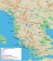
Файл:Map of ancient Epirus and environs (English).svg

Повна роздільність(SVG-файл, номінально 1303 × 1500 пікселів, розмір файлу: 495 КБ)

Wikimedia Commons logo Відомості про цей файл містяться на Вікісховищі — централізованому сховищі вільних файлів мультимедіа для використання у проектах Фонду Вікімедіа.
Перекласти цей файл

Цей SVG-файл містить вкладений текст, який може бути легко перекладений Вашою мовою за допомогою інструменту SVG Translate або будь-якого редактора SVG. Дізнайтесь більше про переклад SVG-файлів.

Опис файлу

Опис
English: Map of ancient Epirus & Environs, Thracian, Illyrian, Paeonian, & Greek contact zones with illustration and extent of Hellenization up to the creation of Epirus Nova or Illyria Graeca
Час створення
Джерело Власна робота
Автор MaryroseB54
Інші версії

[редагувати]

  • The classical age of Greece (1999),
  • ed. Atlas of the Greek and Roman world in antiquity (1981).
  • Hammond, N. G. L. A History of Greece to 322 B.C., 1986, ISBN-10: 0198730950
  • Wilkes, J. J. The Illyrians, 1992,ISBN 0631198075, (i.e. pages 174, 208, 210, 273)
  • In the Shadow of Olympus: The Emergence of Macedon,ISBN 0691008809,1992
  • Thracian Tribal areas (from Fol, Thrace and the Thracians, p 133),The Thracians 700 BC–AD 46 (Men-at-Arms 360) by Christopher Webber After Hoddinot, Col & Cah
  • Hendry, p. 299. The geography is entirely correct for Servius' time, since Diocletian's rearrangement of provincial boundaries included the creation of the province of Epirus Nova out of southern Illyricum with Dyrrachium (=Epidamnus) as its capital.
  • The Loeb Editor's Notes, 28 Nova Epirus or Illyris Graeca (Epirus, Nova Illyria Graeca) "Nova Epirus or Illyris Graeca extended from the Drilo (Mod. Drina) River on the north to the Ceraunian Mts. on the south, thus comprising a large part of modern Albania. Immediately to the south of it to the Ambracian Gulf (Mod. Gulf of Arta) lay what is here called Old Epirus, approximately identical with the Epirus of modern Greece."
  • Soustal, Peter; Koder, Johannes (1981). Tabula Imperii Byzantini, Band 3: Nikopolis und Kephallenia (in German). Vienna: Verlag der Osterreichischen Akademie der Wissenschaften. ISBN 3-7001-0399-9., page 47
  • A new classical dictionary of Greek and Roman biography, mythology, and geography: partly based upon the Dictionary of Greek and Roman biography and mythology by Sir William Smith,1851,page 392 "B. Illyris Graeca, which was called in later times Epirus Nova, extended from the river Drilo to the SE., up to the Ceraunian mountains, which separated it from Epirus Proper"
  • American journal of philology, Τόμοι 98-99,by JSTOR (Organization), Project Muse,1977,page 263, the partly Hellenic and partly Hellenized Epirus Nova
  • Epirus Vetus: The Archaeology of a Late Antique Province (Duckworth Archaeology) by William Bowden,2003,ISBN-10: 0715631160,2003,page 233,of Lissos in Epirus Nova
  • Migrations and invasions in Greece and adjacent areas by Nicholas Geoffrey Lempriere Hammond,1976,ISBN -0815550472,page 54,The line of division between Illyricum and the Greek area Epirus nova
  • Athanassakis, A.N. (1977), "N.G.L. Hammond, Migrations and Invasions in Greece and Adjacent Areas (review)", American Journal of Philology 99: 263–6, JSTOR 293653
  • Hammond, N. G. L. A History of Greece to 322 B.C., 1986, ISBN-10: 0198730950
  • Triadafilopoulos, Triadafilos (November 2000). "Power politics and nationalist discourse in the struggle for 'Northern Epirus': 1919-1921". Journal of Southern Europe and the Balkans,
  • Encyclopedia Britannica,2002,ISBN -0852297874,The Roman province of Illyricum stretched from the Drilon River (the Drin, in modern Albania) in the south to Istria (modem Slovenia and Croatia)
  • History of the Byzantine Empire: Vol. 1, 324-1453 (Paperback) by Alexander A. Vasiliev
  • Epire, Illyrie, Macedoine: melanges offerts au professeur Pierre Cabanes by Daniele Berranger,Pierre Cabanes,Daniele Berranger-Auserve,page 130
  • In An Inventory of Archaic and Classical Poleis by Mogens Herman, ISBN 0-19-814099-1, 2004, i.e. "As a long-distance trading community, Aigina was not an active coloniser, but colonised Kydonia (no. 968) in 519, Adria (no. 75) c.C61, and Damastion in Illyria after 431 (Strabo 8.6.16)." & page 348
  • The Cambridge Ancient History: The Hellenistic monarchies and the rise of Rome, 1964. page 836 "of mixed barbarian and Greek population, such as Dimale (or Dimallum), of unknown"
  • The Illyrian Atintani, the Epirotic Atintanes and the Roman Protectorate N. G. L. Hammond, The Journal of Roman Studies Vol. 79 (1989), pp. 11-25 "There were Illyrian Amantini in Pannonia and Greek Amantes in North Epirus"
  • Blank map from Image:Map greek sanctuaries-fr.svg (The empty map used is not topographic, nor does it offer the capacity of gps precision, but its easy on the eyes and aesthetically pleasing in general)

Ліцензування

Я, власник авторських прав на цей твір, добровільно публікую його на умовах такої ліцензії:
w:uk:Creative Commons
зазначення авторства поширення на тих же умовах
Ви можете вільно:
  • ділитися – копіювати, поширювати і передавати твір
  • модифікувати – переробляти твір
При дотриманні таких умов:
  • зазначення авторства – Ви повинні вказати авторство, надати посилання на ліцензію і вказати, чи якісь зміни було внесено до оригінального твору. Ви можете зробити це в будь-який розсудливий спосіб, але так, щоб він жодним чином не натякав на те, наче ліцензіар підтримує Вас чи Ваш спосіб використання твору.
  • поширення на тих же умовах – Якщо ви змінюєте, перетворюєте або створюєте іншу похідну роботу на основі цього твору, ви можете поширювати отриманий у результаті твір тільки на умовах такої ж або сумісної ліцензії.
Анотації
InfoField
Це зображення має анотації: Переглянути анотації на Вікісховищі

Підписи

Додайте однорядкове пояснення, що саме репрезентує цей файл

Об'єкти, показані на цьому файлі

зображує

Історія файлу

Клацніть на дату/час, щоб переглянути, як тоді виглядав файл.

Дата/часМініатюраРозмір об'єктаКористувачКоментар
поточний04:38, 22 листопада 2021Мініатюра для версії від 04:38, 22 листопада 20211303 × 1500 (495 КБ)KhirurgMeant to upload this version
04:22, 22 листопада 2021Мініатюра для версії від 04:22, 22 листопада 20211303 × 1500 (495 КБ)KhirurgMade some corrections
01:36, 28 грудня 2020Мініатюра для версії від 01:36, 28 грудня 20201303 × 1500 (493 КБ)CastellFile uploaded using svgtranslate tool (https://svgtranslate.toolforge.org/). Added translation for ca.
01:26, 28 грудня 2020Мініатюра для версії від 01:26, 28 грудня 20201303 × 1500 (492 КБ)CastellFile uploaded using svgtranslate tool (https://svgtranslate.toolforge.org/). Added translation for ca.
11:15, 24 червня 2016Мініатюра для версії від 11:15, 24 червня 20161303 × 1500 (383 КБ)MaryroseB54Parthos
23:58, 22 червня 2016Мініатюра для версії від 23:58, 22 червня 20161303 × 1500 (382 КБ)MaryroseB54as per source
22:52, 22 червня 2016Мініатюра для версії від 22:52, 22 червня 20161303 × 1500 (382 КБ)MaryroseB54Position
21:07, 22 червня 2016Мініатюра для версії від 21:07, 22 червня 20161303 × 1500 (382 КБ)MaryroseB54Position fix
10:06, 20 червня 2016Мініатюра для версії від 10:06, 20 червня 20161303 × 1500 (382 КБ)MaryroseB54User created page with UploadWizard

Глобальне використання файлу

Цей файл використовують такі інші вікі:

Переглянути сторінку глобального використання цього файлу.

Метадані