Файл:DG Ariel Plantation.jpg

Розмір при попередньому перегляді: 750 × 600 пікселів. Інші роздільності: 300 × 240 пікселів | 600 × 480 пікселів | 960 × 768 пікселів | 1280 × 1024 пікселів | 1500 × 1200 пікселів.
Повна роздільність (1500 × 1200 пікселів, розмір файлу: 162 КБ, MIME-тип: image/jpeg)
| Відомості про цей файл містяться на Вікісховищі — централізованому сховищі вільних файлів мультимедіа для використання у проектах Фонду Вікімедіа. |
Опис файлу
| Опис |
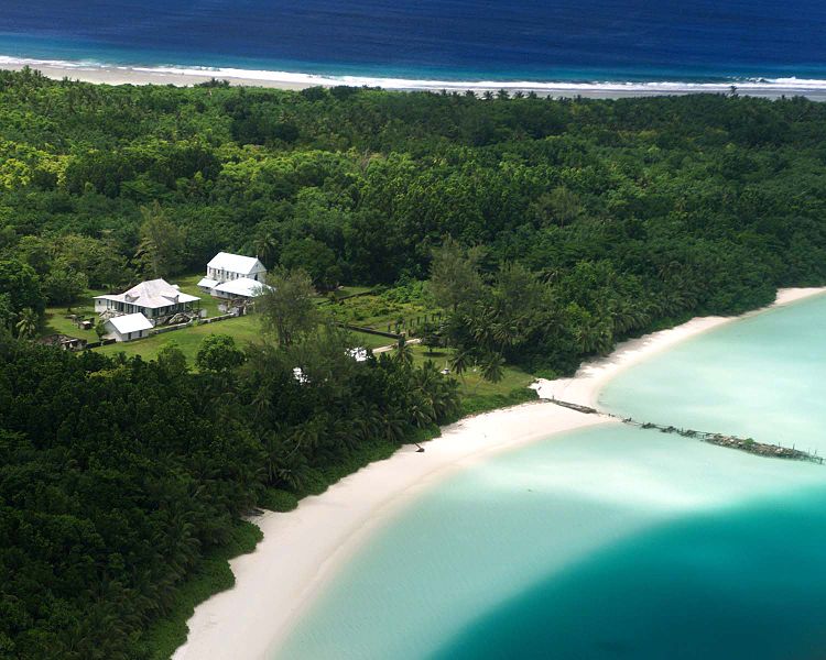
English: Aerial photograph of the coconut plantation at East Point, Diego Garcia. Photograph shows strip of land between both ocean and lagoon.
The island hosts a large airstrip used by the U.S. Armed forces during the Gulf war for operating B-52s. U.S. Submarines and Navy Seal teams have also populated the island in the past. In 1986 The USS Saratoga (CV 60) was docked at the island when it was called away to respond to threats by Lybian Leader Momar Kadaffi and the "Line of Death" in the Gulf of Sidra (also known as the Gulf of Sirte). The carrier left its port while many of its ±4500 sailors were still on the island, which subsequently had to be airlifted via helicopter as the ship made its way to the Mediterranean. The Saratoga spearheaded the assault on the African Nation. |
| Джерело | |
| Автор |
Ліцензування
Ця робота перебуває в суспільному надбанні в США, оскільки вона є роботою Федерального уряду Сполучених Штатів Америки відповідно до розділу 17, параграфу 1, статті 105 Кодексу США (див. Авторське право).
Увага: Це стосується лише робіт Федерального Уряду США, а не робіт окремих штатів, територій, співдружностей, округів, міст, чи інших територіальних одиниць (див. шаблони-ліцензії штатів). Цей шаблон також не може бути використаний для поштових марок Поштової служби США випущених з 1978 року (див. § 313.6(C)(1) Збірки досвіду з авторського права США). Також це стосується деяких монет США (див. Правила Монетного двору США).
|
 | |
| Цей файл визнано вільним від відомих обмежень з боку закону про авторські права, включаючи всі пов'язані і суміжні права. | ||
Журнал завантажень локального файлу
Оригінальна сторінка опису знаходилась тут. Усі нижчезазначені імена користувачів стосуються en.wikipedia.
- 2005-12-27 07:37 Jgrimmer 1500×1200×8 (166195 bytes) Ariel photograph of the coconut plantation at East Point, Diego Garcia. Photograph shows stip of land between both ocean and lagoon.
Історія файлу
Клацніть на дату/час, щоб переглянути, як тоді виглядав файл.
| Дата/час | Мініатюра | Розмір об'єкта | Користувач | Коментар | |
|---|---|---|---|---|---|
| поточний | 13:00, 20 квітня 2008 | | 1500 × 1200 (162 КБ) | File Upload Bot (Magnus Manske) | {{BotMoveToCommons|en.wikipedia}} {{Information |Description={{en|Aerial photograph of the coconut plantation at East Point, Diego Garcia. Photograph shows strip of land between both ocean and lagoon. The island hosts a large airstrip used by the U.S. |
Використання файлу
Такі сторінки використовують цей файл:
Глобальне використання файлу
Цей файл використовують такі інші вікі:
- Використання в ast.wikipedia.org
- Використання в be.wikipedia.org
- Використання в ca.wikipedia.org
- Використання в ceb.wikipedia.org
- Використання в cy.wikipedia.org
- Використання в en.wikipedia.org
- Використання в eo.wikipedia.org
- Використання в es.wikipedia.org
- Використання в fa.wikipedia.org
- Використання в fr.wikipedia.org
- Використання в ga.wikipedia.org
- Використання в gl.wikipedia.org
- Використання в he.wikipedia.org
- Використання в hi.wikipedia.org
- Використання в it.wikipedia.org
- Використання в mk.wikipedia.org
- Використання в ml.wikipedia.org
- Використання в mn.wikipedia.org
- Використання в ne.wikipedia.org
- Використання в nl.wikipedia.org
- Використання в no.wikipedia.org
- Використання в os.wikipedia.org
- Використання в pt.wikipedia.org
- Використання в sh.wikipedia.org
- Використання в simple.wikipedia.org
- Використання в sr.wikipedia.org
- Використання в ta.wikipedia.org
- Використання в www.wikidata.org
- Використання в zh.wikipedia.org