Файл:Cheshire outline map with UK.png
Нема версії з більшою роздільністю.
Cheshire_outline_map_with_UK.png (722 × 552 пікселів, розмір файлу: 412 КБ, MIME-тип: image/png)
| Відомості про цей файл містяться на Вікісховищі — централізованому сховищі вільних файлів мультимедіа для використання у проектах Фонду Вікімедіа. |
Опис файлу
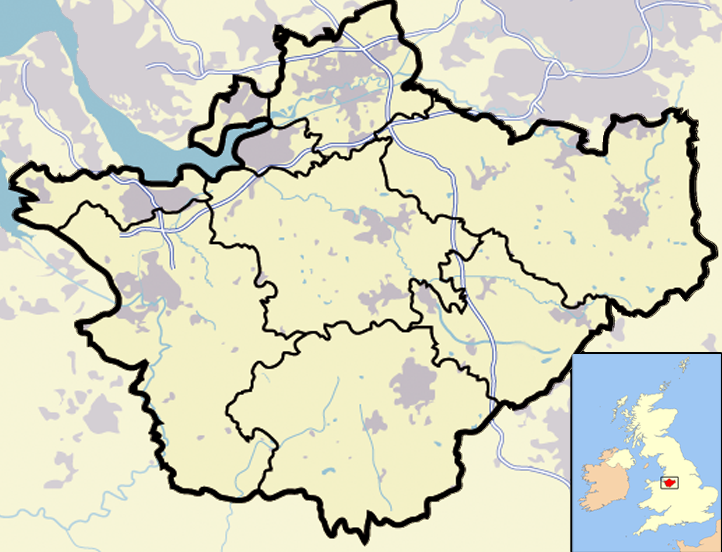
| Опис | Map of en:Cheshire and surrounding area, with micromap of the British Isles for context. Urban areas are shown in grey, water bodies in light-blue, motorways in blue with white stripe and county and borough boundaries in black. |
| Час створення | 29 березня 2007 (дата завантаження оригінального файлу) |
| Джерело | Перенесено з en.wikipedia на Вікісховище. |
| Автор | Jhamez84 з англійська Вікіпедія |
| Інші версії |
.png) (for boundaries expected to come into effect for 2009). (for boundaries expected to come into effect for 2009). |
Ліцензування
| Ця робота була передана у суспільне надбання її автором, Jhamez84 з англійська Вікіпедія. Це застосовується по всьому світу. У деяких країнах це не може бути юридично можливо, в такому випадку: Jhamez84 дає кожному право на використання цієї роботи для будь-яких цілей, без будь-яких умов, якщо такі умови не вимагаються за законом. |
Журнал завантажень локального файлу
Оригінальна сторінка опису знаходилась тут. Усі нижчезазначені імена користувачів стосуються en.wikipedia.
- 2007-04-11 23:50 Jhamez84 722×552×8 (421996 bytes) correcting positioning of some urban areas (they were too east-northeasterly)
- 2007-04-11 17:14 Jhamez84 722×552×8 (420187 bytes) fixing issues in and around the [[M6 motorway]] (moving it to the west per discussion)
- 2007-04-11 00:38 Jhamez84 722×552×8 (438177 bytes) Much more detailed (and thus hopefully more accurate) version of the [[Cheshire]] map.
- 2007-03-29 23:48 Jhamez84 800×558×8 (446798 bytes) Map of [[Cheshire]] and surrounding area, with micromap of the British Isles for context. Urban areas are shown in grey, water bodies in light-blue, motorways in blue with white stripe and county and borough boundaries in black.
Історія файлу
Клацніть на дату/час, щоб переглянути, як тоді виглядав файл.
| Дата/час | Мініатюра | Розмір об'єкта | Користувач | Коментар | |
|---|---|---|---|---|---|
| поточний | 13:02, 23 червня 2008 | | 722 × 552 (412 КБ) | Jza84 | removed erroneous urban area |
| 20:55, 29 червня 2007 |  | 722 × 552 (412 КБ) | Pit-yacker | {{Information |Description=Map of en:Cheshire and surrounding area, with micromap of the British Isles for context. Urban areas are shown in grey, water bodies in light-blue, motorways in blue with white stripe and county and borough boundaries in bl |
Використання файлу
Така сторінка використовує цей файл:
Глобальне використання файлу
Цей файл використовують такі інші вікі:
- Використання в ar.wikipedia.org
- Використання в ceb.wikipedia.org
- Використання в en.wikipedia.org
- Використання в eo.wikipedia.org
- Використання в ga.wikipedia.org
- Використання в ml.wikipedia.org
- Використання в pt.wikipedia.org
- Використання в ro.wikipedia.org
- Використання в sv.wikipedia.org
- Використання в tt.wikipedia.org
- Використання в www.wikidata.org