Файл:Approaching the Larsen Ice Shelf.jpg

Повна роздільність (2889 × 1905 пікселів, розмір файлу: 2,04 МБ, MIME-тип: image/jpeg)
| Відомості про цей файл містяться на Вікісховищі — централізованому сховищі вільних файлів мультимедіа для використання у проектах Фонду Вікімедіа. |
| Опис |
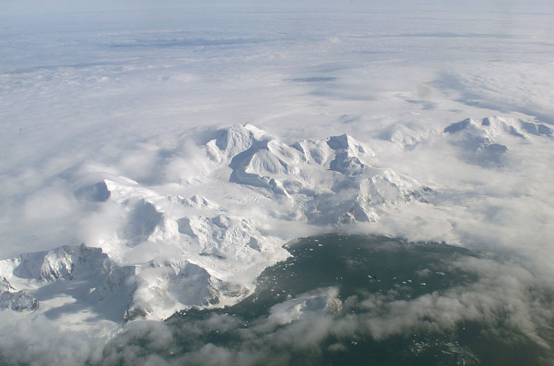
English: An AirSAR 2004 view from the DC-8 as it approaches the Larsen Ice Shelf, which is part of the Antarctic Peninsula.
An AirSAR 2004 view from the DC-8 as it approaches the Larsen Ice Shelf, which is part of the Antarctic Peninsula. AirSAR 2004 is a three-week expedition in Central and South America by an international team of scientists that is using an all-weather imaging tool, called the Airborne Synthetic Aperture Radar (AirSAR), located onboard NASA's DC-8 airborne laboratory. Scientists from many parts of the world are combining ground research with NASA's AirSAR technology to improve and expand on the quality of research they are able to conduct. These photos are from the DC-8 aircraft while flying an AirSAR mission over Antarctica. The Antarctic Peninsula is more similar to Alaska and Patagonia than to the rest of the Antarctic continent. It is drained by fast glaciers, receives abundant precipitation, and melts significantly in the summer months. In recent decades, the Peninsula has experienced significant atmospheric warming (about 2 degrees C since 1950), which has triggered a vast and spectacular retreat of its floating ice shelves, glacier reduction, a decrease in permanent snow cover and a lengthening of the melt season. As a result, the contribution to sea level from this region could be rapid and substantial. With an area of 120,000 km, or ten times the Patagonia ice fields, the Peninsula could contribute as much as 0.4mm/yr sea level rise, which would be the largest single contribution to sea level from anywhere in the world. This region is being studied by NASA using a DC-8 equipped with the Airborne Synthetic Aperture Radar developed by scientists from NASA’s Jet Propulsion Laboratory. AirSAR will provide a baseline model and unprecedented mapping of the region. This data will make it possible to determine whether the warming trend is slowing, continuing or accelerating. AirSAR will also provide reliable information on ice shelf thickness to measure the contribution of the glaciers to sea level. AirSAR collects multi-frequency and multi-polarization radar data for a variety of science applications. It also acquires data in interferometric modes, providing topographic information (cross-track mode) or ocean current information (along-track interferometry). This March 2004 deployment was planned to:
|
| Час створення | |
| Джерело | NASA Photo Number: ED04-0056-110 |
| Автор | NASA Photo by: Jim Ross |
Це зображення або відео внесене у каталог Льотно-дослідницького центру Армстронга Національного управління з аеронавтики і дослідження космічного простору США (NASA)під фото ID: ED04-0056-110. Це не тег авторських прав. Дійсна ліцензія має додаватись до цього тегу. Інші мови:
|
| Цей файл перебуває у суспільному надбанні, оскільки він був створений NASA (Національним управлінням з аеронавтики і дослідження космічного простору). Згідно з політикою NASA стосовно авторського права, «матеріали NASA не захищаються авторським правом, якщо не вказано протилежне». (Див. Template:PD-USGov, сторінку політики NASA стосовно авторського права, або політику використання зображень JPL.) | ||
 |
Попередження:
|
Історія файлу
Клацніть на дату/час, щоб переглянути, як тоді виглядав файл.
| Дата/час | Мініатюра | Розмір об'єкта | Користувач | Коментар | |
|---|---|---|---|---|---|
| поточний | 09:21, 8 липня 2008 | | 2889 × 1905 (2,04 МБ) | Finavon | caption cropped |
| 18:50, 13 січня 2007 |  | 2889 × 2400 (2,23 МБ) | Uwe W. | An AirSAR 2004 view from the DC-8 as it approaches the Larsen Ice Shelf, which is part of the Antarctic Peninsula. Photo Number: ED04-0056-110<br> Photo Date: March 13, 2004<br> Formats: 578x480 JPEG Image (141 KBytes)<br> 1233x1024 JPEG Image |
Використання файлу
Така сторінка використовує цей файл:
Глобальне використання файлу
Цей файл використовують такі інші вікі:
- Використання в en.wikipedia.org
- Використання в eo.wikipedia.org
- Використання в fr.wikipedia.org
- Використання в it.wikipedia.org
- Використання в ja.wikipedia.org
- Використання в no.wikipedia.org
- Використання в ru.wikipedia.org
- Використання в simple.wikipedia.org
- Використання в tr.wikipedia.org
- Використання в zh.wikipedia.org