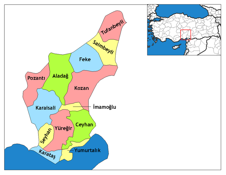
Файл:Adana districts.png

Розмір при попередньому перегляді: 776 × 600 пікселів. Інші роздільності: 311 × 240 пікселів | 621 × 480 пікселів | 994 × 768 пікселів | 1056 × 816 пікселів.
Повна роздільність (1056 × 816 пікселів, розмір файлу: 42 КБ, MIME-тип: image/png)
Історія файлу
Клацніть на дату/час, щоб переглянути, як тоді виглядав файл.
| Дата/час | Мініатюра | Розмір об'єкта | Користувач | Коментар | |
|---|---|---|---|---|---|
| поточний | 19:38, 28 грудня 2008 |  | 1056 × 816 (42 КБ) | One Homo Sapiens | Corrected text where İ,Ş,ı,ğ,or ş occurs in name. Increased font size and enhanced color differences among adjacent districts. Additional source: Adana Valiliği [adana-gov-tr]. |
| 19:54, 28 січня 2007 |  | 1056 × 816 (46 КБ) | Makalp | {{Information |Description=Map of the districts of Adana province in Turkey. |Source=Created by Rarelibra 22:15, 13 November 2006 (UTC) for public domain use, using MapInfo Professional v8.5 and various mapping resources. |Date=28.01.2 | |
| 19:52, 28 січня 2007 |  | 1056 × 816 (46 КБ) | Makalp | {{Information |Description=Map of the districts of Adana province in Turkey. |Source=Created by Rarelibra 22:15, 13 November 2006 (UTC) for public domain use, using MapInfo Professional v8.5 and various mapping resources. |Date=28.01.2 | |
| 19:46, 28 січня 2007 |  | 1056 × 816 (46 КБ) | Makalp | {{Information |Description=Map of the districts of Adana province in Turkey. Created by Rarelibra 22:15, 13 November 2006 (UTC) for public domain use, using MapInfo Professional v8.5 and various mapping resources. |Source=Mustafa Akalp | |
| 19:40, 28 січня 2007 |  | 1056 × 816 (46 КБ) | Makalp | {{ew|en|Rarelibra}} == Summary == Map of the districts of Adana province in Turkey. Created by Rarelibra 22:15, 13 November 2006 (UTC) for public domain use, using MapInfo Professional v8.5 and various mapping resources. == Licensing = | |
| 09:39, 17 грудня 2006 |  | 1056 × 816 (33 КБ) | Electionworld | {{ew|en|Rarelibra}} == Summary == Map of the districts of Adana province in Turkey. Created by Rarelibra 22:15, 13 November 2006 (UTC) for public domain use, using MapInfo Professional v8.5 and various mapping resources. == Licensing = |
Використання файлу
Така сторінка використовує цей файл:
Глобальне використання файлу
Цей файл використовують такі інші вікі:
- Використання в ar.wikipedia.org
- Використання в avk.wikipedia.org
- Використання в azb.wikipedia.org
- Використання в az.wikipedia.org
- Використання в be.wikipedia.org
- Використання в bg.wikipedia.org
- Використання в br.wikipedia.org
- Використання в ca.wikipedia.org
- Використання в de.wikipedia.org
- Işıklı (Kozan)
- Wikipedia:Kartenwerkstatt/Archiv/2011-01
- Zerdali
- Yüksekören (Kozan)
- Tepecikören
- Enizçakırı
- Doğanalanı
- Damyeri
- Bağtepe (Kozan)
- Yukarıkeçili
- Yeniköy (Kozan)
- Yassıçalı
- Yanalerik
- Velicanlı
- Turunçlu (Kozan)
- Tufanlı
- Şerifli
- Salmanlı (Kozan)
- Postkabasakal
- Pekmezci (Kozan)
- Özbaşı (Kozan)
- Örendere
- Oruçlu (Kozan)
- Minnetli
- Marankeçili
- Mahyalar
- Kuyuluk (Kozan)
- Kuyubeli
- Kuytucak
- Köseli (Kozan)
- Kızlarsekisi
- Kızıllar (Kozan)
- Kıbrıslar
- Kemerköy (Kozan)
- Karanebili
- Karahamzalı (Kozan)
- Karabucak (Kozan)
- Kapıkaya (Kozan)
- Kalkumaç
Переглянути сторінку глобального використання цього файлу.
