Файл:Venus dome 3D.jpg

Розмір при попередньому перегляді: 750 × 600 пікселів. Інші роздільності: 300 × 240 пікселів | 600 × 480 пікселів | 960 × 768 пікселів | 1280 × 1024 пікселів | 2560 × 2048 пікселів | 5000 × 4000 пікселів.
Повна роздільність (5000 × 4000 пікселів, розмір файлу: 1,17 МБ, MIME-тип: image/jpeg)
| Відомості про цей файл містяться на Вікісховищі — централізованому сховищі вільних файлів мультимедіа для використання у проектах Фонду Вікімедіа. |
Опис файлу
| Опис |
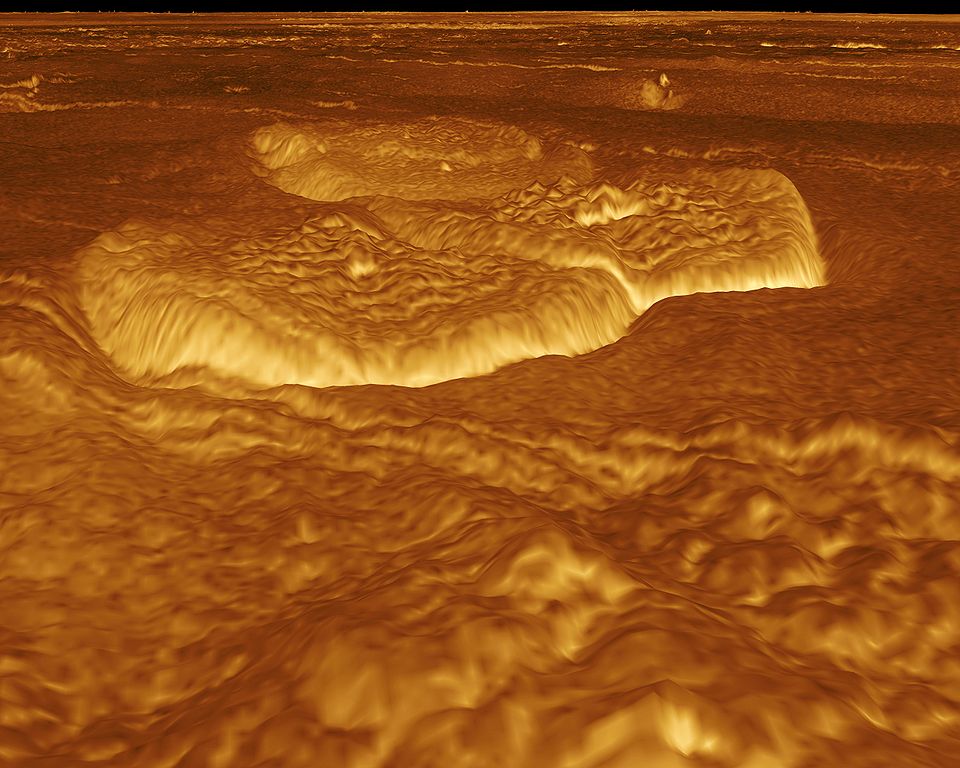
English: A portion of the eastern edge of Alpha Regio is displayed in this three-dimensional perspective view of the surface of Venus. The viewpoint is located at approximately 30 degrees south latitude, 11.8 degrees east longitude at an elevation of 2.4 kilometers (3.8 miles). The view is to the northeast at the center of an area containing seven circular dome-like hills. The average diameter of the hills is 25 kilometers (15 miles) with maximum heights of 750 meters (2,475 feet). Three of the hills are visible in the center of the image. Fractures on the surrounding plains are both older and younger than the domes. The hills may be the result of viscous or thick eruptions of lava coming from a vent on the relatively level ground, allowing the lava to flow in an even lateral pattern. The concentric and radial fracture patterns on their surfaces suggests that a chilled outer layer formed, then further intrusion in the interior stretched the surface. An alternative interpretation is that domes are the result of shallow intrusions of molten lava, causing the surface to rise. If they are intrusive, then magma withdrawal near the end of the eruptions produced the fractures. The bright margins possibly indicate the presence of rock debris or talus at the slopes of the domes. Resolution of the Magellan data is about 120 meters (400 feet). Magellan's synthetic aperture radar is combined with radar altimetry to develop a three-dimensional map of the surface. A perspective view is then generated from the map. Simulated color and a process called radar-clinometry are used to enhance small-scale structures. The simulated hues are based on color images recorded by the Soviet Venera 13 and 14 spacecraft. The image was produced by the JPL Multimission Image Processing Laboratory by Eric De Jong, Jeff Hall, Myche McAuley, and Randy Kirk of the United States Geological Survey, and is a single frame from the movie released at the May 29, 1991 Magellan news conference.
Čeština: Útvary na planetě Venuši, východně od Alpha Regio. Obraz byl vytvořen v laboratoři JPL Multimission Image Processing Laboratory, autory jsou Eric De Jong, Jeff Hall, Myche McAuley a Randy Kirk. Obraz byl získán metodou radarové klinometrie (měření sklonu) a je vyobrazen v nepravých barvách. |
| Час створення | |
| Джерело | http://photojournal.jpl.nasa.gov/catalog/PIA00246 |
| Автор | NASA, JPL Multimission Image Processing Laboratory, U.S Geological Survey |
| Ліцензія (Повторне використання цього файлу) |
http://nssdc.gsfc.nasa.gov/photo_gallery/photogallery-faq.html#use |
Це зображення або відео внесене у каталог Лабораторії реактивного руху Національного управління з аеронавтики і дослідження космічного простору США (NASA)під фото ID: PIA00246. Це не тег авторських прав. Дійсна ліцензія має додаватись до цього тегу. Інші мови:
|
Ліцензування
| Цей файл перебуває у суспільному надбанні, оскільки він був створений NASA (Національним управлінням з аеронавтики і дослідження космічного простору). Згідно з політикою NASA стосовно авторського права, «матеріали NASA не захищаються авторським правом, якщо не вказано протилежне». (Див. Template:PD-USGov, сторінку політики NASA стосовно авторського права, або політику використання зображень JPL.) | ||
 |
Попередження:
|
Історія файлу
Клацніть на дату/час, щоб переглянути, як тоді виглядав файл.
| Дата/час | Мініатюра | Розмір об'єкта | Користувач | Коментар | |
|---|---|---|---|---|---|
| поточний | 21:13, 1 вересня 2005 | | 5000 × 4000 (1,17 МБ) | Bricktop | larger |
| 20:30, 1 вересня 2005 |  | 645 × 516 (45 КБ) | Lotse | *'''Original Caption Released with Image:''' A portion of the eastern edge of Alpha Regio is displayed in this three-dimensional perspective view of the surface of Venus. The viewpoint is located at approximately 30 degrees south latitude, 11.8 degrees e |
Використання файлу
Такі сторінки використовують цей файл:
Глобальне використання файлу
Цей файл використовують такі інші вікі:
- Використання в ar.wikipedia.org
- Використання в ca.wikipedia.org
- Використання в cs.wikipedia.org
- Використання в de.wikipedia.org
- Використання в en.wikipedia.org
- Використання в en.wikiversity.org
- Використання в fr.wikipedia.org
- Використання в hy.wikipedia.org
- Використання в ja.wikipedia.org
- Використання в mk.wikipedia.org
- Використання в nl.wikipedia.org
- Використання в pl.wiktionary.org
- Використання в ru.wikipedia.org
- Використання в zh.wikipedia.org