Файл:Tycho Crater Panorama.jpg
Tycho_Crater_Panorama.jpg (625 × 480 пікселів, розмір файлу: 97 КБ, MIME-тип: image/jpeg)
| Відомості про цей файл містяться на Вікісховищі — централізованому сховищі вільних файлів мультимедіа для використання у проектах Фонду Вікімедіа. |
Опис файлу
| Опис |
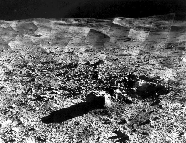
Original caption: " Photomosaic of lunar panorama near the Tycho crater taken by Surveyor 7. The hills on the center horizon are about eight miles away from the spacecraft. "Since the landing site survey for the Apollo missions had been successfully completed by the previous Surveyors, the landing site for Surveyor 7 was selected more for its scientific interest. Surveyor 7, in addition to taking thousands of images and gathering a wide variety of surface data, performed star surveys, took pictures of Earth, and tested laser-pointing techniques by detecting laser beams from Earth. |
| Час створення | between 10-Jan-1968 and 26-Jan-1968 |
| Джерело | http://photojournal.jpl.nasa.gov/catalog/PIA02977 |
| Автор | Courtesy NASA/JPL-Caltech |
| Ліцензія (Повторне використання цього файлу) |
may be used for any purpose without prior permission |
| Місце на Місяці | Перегляньте це та інші зображення поблизу на: Google Карти |
|---|
Ліцензування
| Цей файл перебуває у суспільному надбанні, оскільки він був створений NASA (Національним управлінням з аеронавтики і дослідження космічного простору). Згідно з політикою NASA стосовно авторського права, «матеріали NASA не захищаються авторським правом, якщо не вказано протилежне». (Див. Template:PD-USGov, сторінку політики NASA стосовно авторського права, або політику використання зображень JPL.) | ||
 |
Попередження:
|
Історія файлу
Клацніть на дату/час, щоб переглянути, як тоді виглядав файл.
| Дата/час | Мініатюра | Розмір об'єкта | Користувач | Коментар | |
|---|---|---|---|---|---|
| поточний | 18:07, 14 січня 2006 | | 625 × 480 (97 КБ) | W-j-s | == Summary == Original Caption Released with Image taken from [http://photojournal.jpl.nasa.gov/catalog/PIA02977 jpl site]: Photomosaic of lunar panorama near the Tycho crater taken by Surveyor 7. The hills on the center horizon are about |
Використання файлу
Така сторінка використовує цей файл:
Глобальне використання файлу
Цей файл використовують такі інші вікі:
- Використання в als.wikipedia.org
- Використання в ar.wikipedia.org
- Використання в ca.wikipedia.org
- Використання в cs.wikipedia.org
- Використання в da.wikipedia.org
- Використання в el.wikipedia.org
- Використання в en.wikipedia.org
- Використання в et.wikipedia.org
- Використання в fr.wikipedia.org
- Використання в hu.wikipedia.org
- Використання в id.wikipedia.org
- Використання в io.wikipedia.org
- Використання в it.wikipedia.org
- Використання в ja.wikipedia.org
- Використання в ms.wikipedia.org
- Використання в nl.wikipedia.org
- Використання в nn.wikipedia.org
- Використання в oc.wikipedia.org
- Використання в pl.wikipedia.org
- Використання в ru.wikipedia.org
- Використання в sr.wikipedia.org
- Використання в sv.wikipedia.org
- Використання в ta.wikipedia.org
- Використання в vi.wikipedia.org
- Використання в zh.wikipedia.org