Файл:Tlaxcalamap.jpg
Повна роздільність (3840 × 3000 пікселів, розмір файлу: 2,24 МБ, MIME-тип: image/jpeg)
| Відомості про цей файл містяться на Вікісховищі — централізованому сховищі вільних файлів мультимедіа для використання у проектах Фонду Вікімедіа. |
Опис файлу
| Опис |
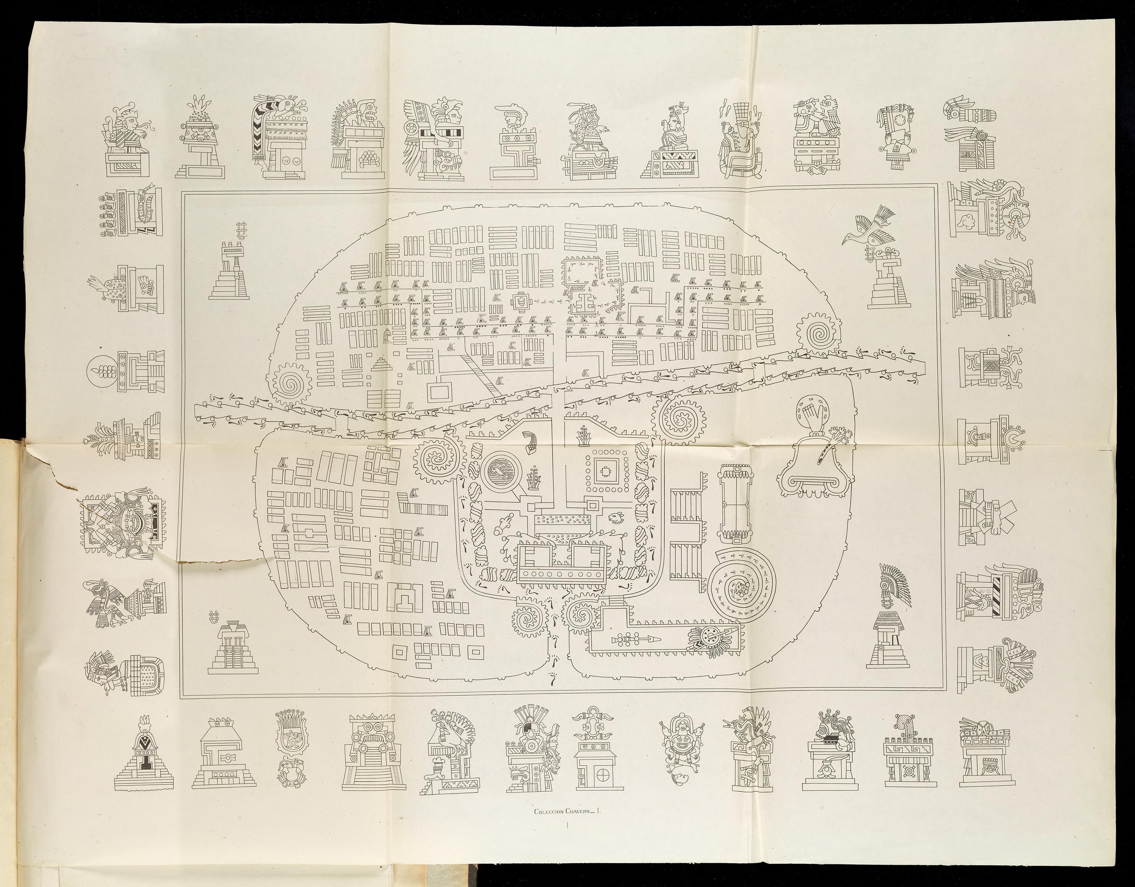
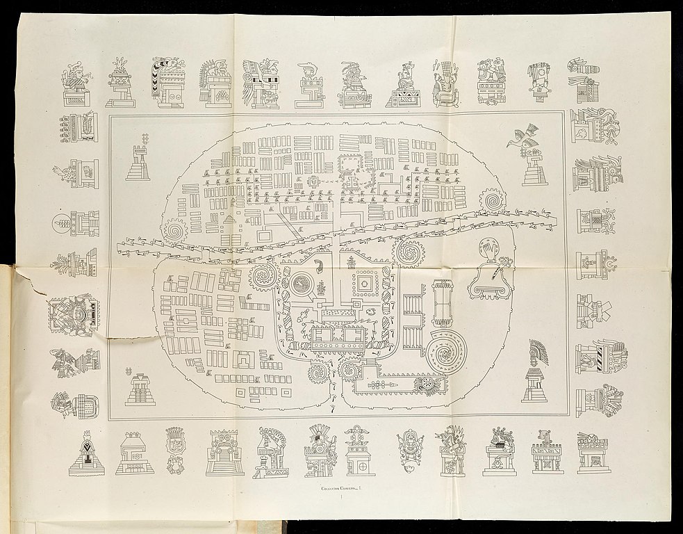
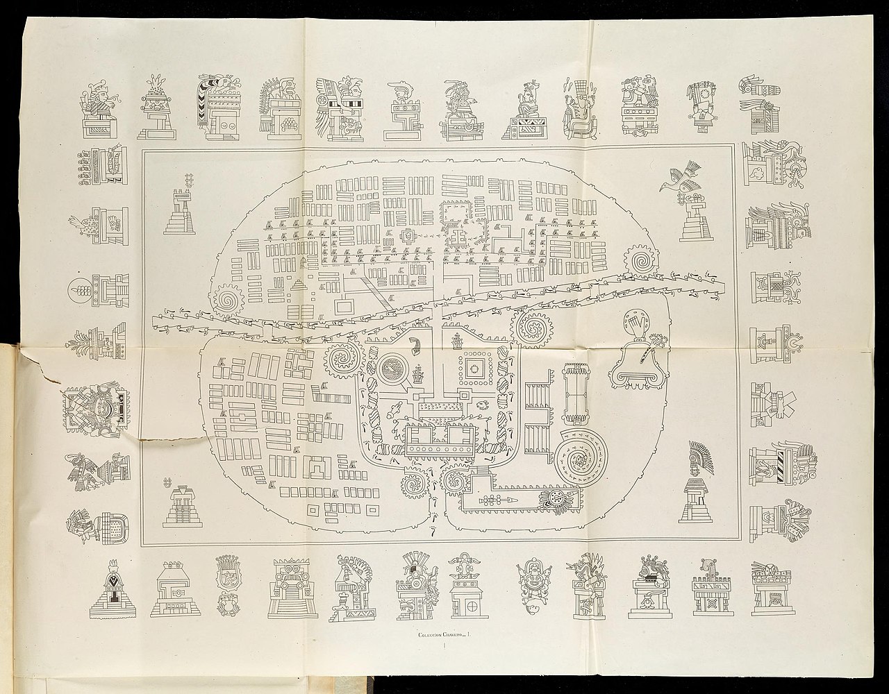
English: A Map of Tlaxcala: The top-right hand sector is Tizatlan, the bottom-right hand sector Quiahuiztlan, the top-left hand sector Ocotelolco, and the bottom-left hand sector Tepeticpac. The river, Atzompa, crosses the city from North to South (left to right, the map being oriented along an East-West axis).
Italiano: Mappa di Tlaxcala.Il settore in alto a destra è Tizatlan, quello in basso a destra è Quiahuiztlan, quello in alto a sinistra è Ocotelolco e quello in basso a sinistra è Tepeticpac. Il fiume, Atzompa, attraversa la città da nord a sud (da sinistra a destra, dato che la mappa è orientata sull'asse est-ovest). Tratta da Alfredo Chavero, Pintures Jeroglificas, Messico, 1901. |
| Час створення | |
| Джерело | Pinturas Jeroglíficas, Mexico: https://archive.org/details/gri_33125009867314 |
| Автор | Alfredo Chavero |
Ліцензування
|
Ця робота перебуває у суспільному надбанні у країнах і територіях, де авторське право охороняється протягом життя автора та 70 років після того або менше.
| |
| Цей файл визнано вільним від відомих обмежень з боку закону про авторські права, включаючи всі пов'язані і суміжні права. | |
Журнал завантажень локального файлу
- 2009-07-06 03:43 Robert M Johnson 871×663× (693169 bytes) == Description == {{Information |Description= Map of the [[Nahuatl]] city [[Tlaxcala]] from the 20th century, |Source=Originally from [http://books.google.com/books?id=o-sMQAovYJoC&pg=PA461&lpg=PA461&dq=Tepeticpac+tlaxcala&source=bl&ots=1y1yM9xzIM&sig=u6
Історія файлу
Клацніть на дату/час, щоб переглянути, як тоді виглядав файл.
| Дата/час | Мініатюра | Розмір об'єкта | Користувач | Коментар | |
|---|---|---|---|---|---|
| поточний | 09:50, 17 червня 2022 | | 3840 × 3000 (2,24 МБ) | ErickTErick | Better version from the same source |
| 14:08, 21 листопада 2009 |  | 871 × 663 (677 КБ) | File Upload Bot (Magnus Manske) | {{BotMoveToCommons|en.wikipedia|year={{subst:CURRENTYEAR}}|month={{subst:CURRENTMONTHNAME}}|day={{subst:CURRENTDAY}}}} {{Information |Description={{en|''no original description''}} |Source=Transferred from [http://en.wikipedia.org en.wikipedia]; transfer |
Використання файлу
Такі сторінки використовують цей файл:
Глобальне використання файлу
Цей файл використовують такі інші вікі:
- Використання в af.wikipedia.org
- Використання в arz.wikipedia.org
- Використання в ca.wikipedia.org
- Використання в cs.wikipedia.org
- Використання в en.wikipedia.org
- Використання в eo.wikipedia.org
- Використання в es.wikipedia.org
- Використання в it.wikipedia.org
- Використання в ja.wikipedia.org
- Використання в pl.wikipedia.org
- Використання в www.wikidata.org