Файл:LuxembourgPartitionsMap francais.jpg
Нема версії з більшою роздільністю.
LuxembourgPartitionsMap_francais.jpg (433 × 588 пікселів, розмір файлу: 111 КБ, MIME-тип: image/jpeg)
| Відомості про цей файл містяться на Вікісховищі — централізованому сховищі вільних файлів мультимедіа для використання у проектах Фонду Вікімедіа. |

|
Це зображення невідомого типу «historical map» має бути конвертоване у векторний формат SVG. Це дає декілька переваг, докладніше про які Ви можете прочитати на сторінці Commons:Media for cleanup. Якщо Вам вже зараз доступна векторна версія даного зображення, завантажте її, будь ласка. Після завантаження замініть цей шаблон на такий: {{vector version available|Назва_завантаженого_файлу.svg}}.
|


Опис файлу
| Опис |
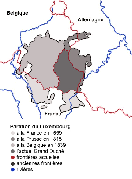
English: Map showing the partition of Luxembourg through the centuries, with French explanations.
Français : Carte montrant la partition du Luxembourg à travers les siècles. |
| Час створення | |
| Джерело |
|
| Автор | Spanish_Inquisition |
| Інші версії |
|


Ліцензування
| Я, власник авторських прав на цю роботу, передаю роботу в суспільне надбання. Застосовується по всьому світу. У деяких країнах це не може бути юридично можливо, в такому випадку: Я даю кожному право на використання цієї роботи для будь-яких цілей, без будь-яких умов, якщо такі умови не вимагаються за законом. |
Історія файлу
Клацніть на дату/час, щоб переглянути, як тоді виглядав файл.
| Дата/час | Мініатюра | Розмір об'єкта | Користувач | Коментар | |
|---|---|---|---|---|---|
| поточний | 09:11, 4 серпня 2007 | | 433 × 588 (111 КБ) | Noelclem | |
| 08:22, 4 серпня 2007 |  | 433 × 588 (101 КБ) | Noelclem | ||
| 15:40, 3 серпня 2007 |  | 433 × 588 (49 КБ) | Iunity | correction orthographe | |
| 14:59, 3 вересня 2006 |  | 433 × 588 (85 КБ) | Spanish Inquisition | Map showing the partition of Luxembourg thorugh the centuries with french expanantions. Modification of the image LuxembourgPartitionsMap.png by user:QuartierLatin1968 14:10, 22 Apr 2005 (UTC). Author: user:Spanish_Inquisition Date: 3rd September 2006 |
Використання файлу
Така сторінка використовує цей файл:
Глобальне використання файлу
Цей файл використовують такі інші вікі:
- Використання в als.wikipedia.org
- Використання в ca.wikipedia.org
- Використання в en.wikipedia.org
- Використання в fr.wikipedia.org
- Luxembourg
- Histoire du Luxembourg
- Formation territoriale de la Belgique
- Frontière entre la France et le Luxembourg
- Wikipédia:Atelier graphique/Images à améliorer/Archives/Août 2007
- Frontière entre la Belgique et le Luxembourg
- Évolution territoriale du Luxembourg
- Frontières du Luxembourg
- Grand-duché de Luxembourg (1815-1890)
- Використання в pcd.wikipedia.org
- Використання в pl.wikipedia.org
- Використання в pt.wikipedia.org