Файл:ISS-30 Lake Fitri, Chad.jpg
Розмір при попередньому перегляді: 800 × 531 пікселів. Інші роздільності: 320 × 213 пікселів | 640 × 425 пікселів | 1024 × 680 пікселів | 1280 × 850 пікселів | 2560 × 1700 пікселів | 4288 × 2848 пікселів.
Повна роздільність (4288 × 2848 пікселів, розмір файлу: 6,37 МБ, MIME-тип: image/jpeg)
| Відомості про цей файл містяться на Вікісховищі — централізованому сховищі вільних файлів мультимедіа для використання у проектах Фонду Вікімедіа. |
Опис файлу
| Опис |
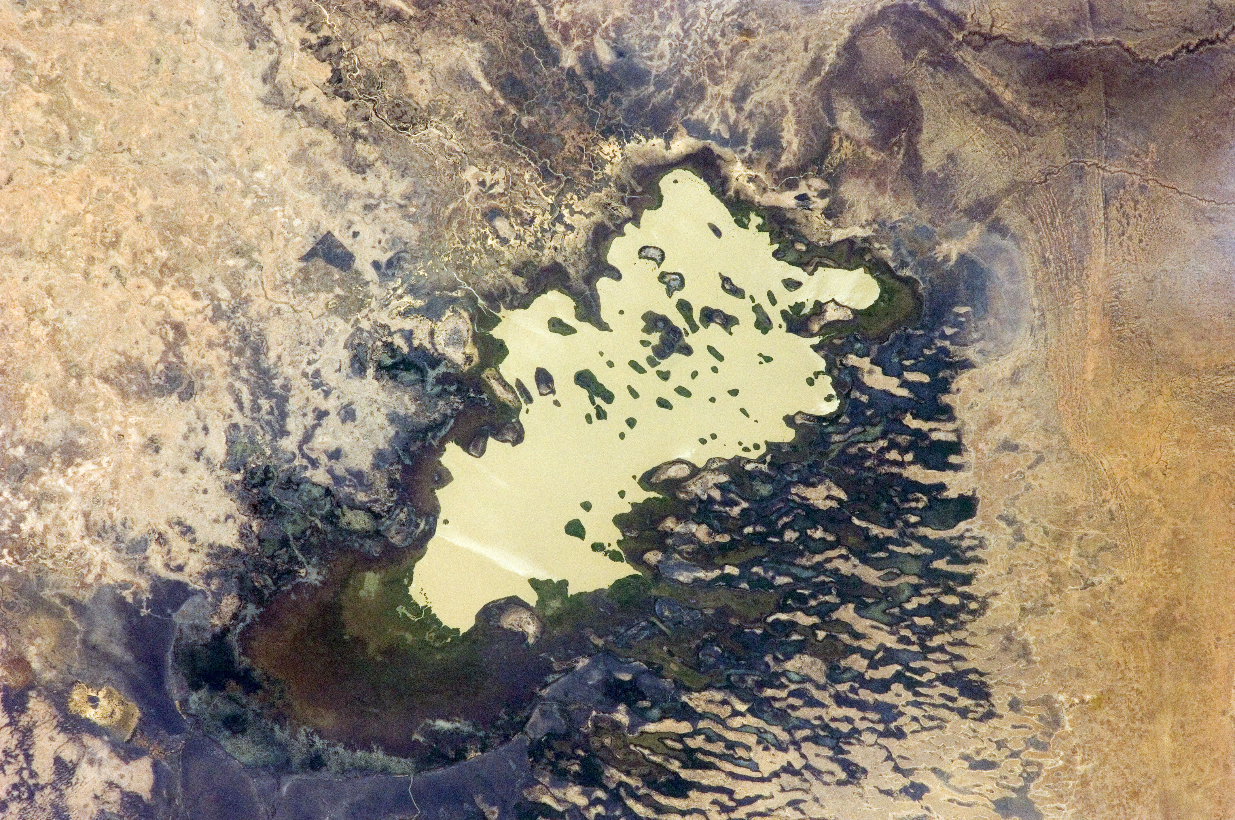
English: Lake Fitri, Chad is featured in this image photographed by an Expedition 30 crew member on the International Space Station.
|
| Час створення | |
| Джерело | http://spaceflight.nasa.gov/gallery/images/station/crew-30/html/iss030e059398.html |
| Автор | NASA |
Це зображення або відео внесене у каталог Космічного центру Ліндона Джонсона Національного управління з аеронавтики і дослідження космічного простору США (NASA)під фото ID: ISS030-E-059398. Це не тег авторських прав. Дійсна ліцензія має додаватись до цього тегу. Інші мови:
|
Ліцензування
This file is in the public domain in the United States because it was created by the Image Science & Analysis Laboratory, of the NASA Johnson Space Center. NASA copyright policy states that "NASA material is not protected by copyright unless noted". (NASA media use guidelines or Conditions of Use of Astronaut Photographs).
Photo source: ISS030-E-59398.
|
Історія файлу
Клацніть на дату/час, щоб переглянути, як тоді виглядав файл.
| Дата/час | Мініатюра | Розмір об'єкта | Користувач | Коментар | |
|---|---|---|---|---|---|
| поточний | 20:00, 20 квітня 2016 | | 4288 × 2848 (6,37 МБ) | Ras67 | new rendered in high quality from NASA's raw image data |
| 12:46, 4 червня 2012 |  | 4288 × 2848 (2,03 МБ) | Ras67 | levels | |
| 17:59, 21 лютого 2012 |  | 4288 × 2848 (1,76 МБ) | Ras67 | {{Information |Description ={{en|1=Lake Fitri, Chad is featured in this image photographed by an Expedition 30 crew member on the International Space Station. Lake Fitri is an endorheic, or terminal lake in a desert basin in the southern Sahara Desert. |
Використання файлу
Така сторінка використовує цей файл:
Глобальне використання файлу
Цей файл використовують такі інші вікі:
- Використання в ar.wikipedia.org
- Використання в arz.wikipedia.org
- Використання в be.wikipedia.org
- Використання в cv.wikipedia.org
- Використання в de.wikipedia.org
- Використання в el.wikipedia.org
- Використання в en.wikipedia.org
- Використання в es.wikipedia.org
- Використання в fr.wikipedia.org
- Використання в id.wikipedia.org
- Використання в it.wikipedia.org
- Використання в ka.wikipedia.org
- Використання в lt.wikipedia.org
- Використання в my.wikipedia.org
- Використання в nl.wikipedia.org
- Використання в pl.wikipedia.org
- Використання в ru.wikipedia.org
- Використання в vi.wikipedia.org
- Використання в www.wikidata.org