Файл:EXTERIOR VIEW, FRONT ELEVATION - Corry Homestead, Corry House, State Route 69, 10 miles South of Jasper (244 School Street), Oakman, Walker County, AL HABS ALA,64-OAK,A-1.tif

Розмір цього попереднього перегляду JPG для вихідного TIF-файлу: 800 × 584 пікселів. Інші роздільності: 320 × 234 пікселів | 640 × 468 пікселів | 1024 × 748 пікселів | 1280 × 935 пікселів | 2560 × 1870 пікселів | 5000 × 3653 пікселів.
Повна роздільність (5000 × 3653 пікселів, розмір файлу: 17,42 МБ, MIME-тип: image/tiff)
| Відомості про цей файл містяться на Вікісховищі — централізованому сховищі вільних файлів мультимедіа для використання у проектах Фонду Вікімедіа. |
Опис файлу
| EXTERIOR VIEW, FRONT ELEVATION - Corry Homestead, Corry House, State Route 69, 10 miles South of Jasper (244 School Street), Oakman, Walker County, AL | ||||
|---|---|---|---|---|
| Фотограф |
Related names:
|
|||
| Заголовок |
EXTERIOR VIEW, FRONT ELEVATION - Corry Homestead, Corry House, State Route 69, 10 miles South of Jasper (244 School Street), Oakman, Walker County, AL |
|||
| Зображене місце | Alabama; Walker County; Oakman | |||
| Час створення | Documentation compiled after 1933 | |||
| Розміри | 8 x 10 in. | |||
| Розміщення |
Library of Congress Prints and Photographs Division Washington, D.C. 20540 USA http://hdl.loc.gov/loc.pnp/pp.print |
|||
| Інвентарний номер |
HABS ALA,64-OAK,A-1 |
|||
| Джерело походження |
|
|||
| Нотатки |
|
|||
| Джерело | https://www.loc.gov/pictures/item/al1160.photos.046569p | |||
| Ліцензія (Повторне використання цього файлу) |
|
|||

| Місцеположення об’єкта | | Перегляньте це та інші зображення поблизу на: OpenStreetMap |
|---|
Історія файлу
Клацніть на дату/час, щоб переглянути, як тоді виглядав файл.
| Дата/час | Мініатюра | Розмір об'єкта | Користувач | Коментар | |
|---|---|---|---|---|---|
| поточний | 03:08, 1 липня 2014 | 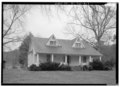 | 5000 × 3653 (17,42 МБ) | Fæ | GWToolset: Creating mediafile for Fæ. HABS batch upload 29 June 2014 (101:150) |
Використання файлу
Така сторінка використовує цей файл:
Глобальне використання файлу
Цей файл використовують такі інші вікі:
- Використання в ar.wikipedia.org
- Використання в arz.wikipedia.org
- Використання в ca.wikipedia.org
- Використання в ceb.wikipedia.org
- Використання в ce.wikipedia.org
- Використання в cy.wikipedia.org
- Використання в es.wikipedia.org
- Використання в eu.wikipedia.org
- Використання в fr.wikipedia.org
- Використання в ht.wikipedia.org
- Використання в it.wikipedia.org
- Використання в lld.wikipedia.org
- Використання в no.wikipedia.org
- Використання в pl.wikipedia.org
- Використання в pt.wikipedia.org
- Використання в sr.wikipedia.org
- Використання в tt.wikipedia.org
- Використання в uz.wikipedia.org
- Використання в vi.wikipedia.org
- Використання в www.wikidata.org
- Використання в zh-min-nan.wikipedia.org