Файл:Dean Architects - fmr Railway Branch YMCA - Depew, New York - 20210219.jpg

Розмір при попередньому перегляді: 800 × 599 пікселів. Інші роздільності: 320 × 240 пікселів | 640 × 480 пікселів | 1024 × 767 пікселів | 1280 × 959 пікселів | 1791 × 1342 пікселів.
Повна роздільність (1791 × 1342 пікселів, розмір файлу: 833 КБ, MIME-тип: image/jpeg)
| Відомості про цей файл містяться на Вікісховищі — централізованому сховищі вільних файлів мультимедіа для використання у проектах Фонду Вікімедіа. |
Опис файлу
| Опис |
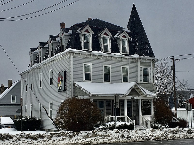
English: Dean Architects, 3284 Walden Avenue at Tyler Street, Depew, New York, February 2021. Erected in 1896 as one of the first batch of institutional buildings built by the Depew Improvement Company for the then-newly founded village, this serves as an anachronistic example of the Second Empire architectural style with its bracketed cornice, pedimented dormer windows framed by stylized columns, and of course, proud mansard roof. However, the shingle-sided, tent-roofed corner turret and the asymmetrical front porch with its off-center pediment both borrow from the Queen Anne style, which was much less passé at the time. The building functioned initially as the so-called Railroad Branch YMCA, which appears to have been defunct by 1912: a Depew Herald article from that year mentions a proposal to move the "former Y.M.C.A. building" to nearby Transit Road and convert it to a hotel, which apparently never materialized as the building remains on its original site. By 1939 it was in use as apartments, initially with a modest but respectable lower-middle-class tenant base composed mainly of workers at the machine shops and factories gathered around the New York Central Railroad line; the village's raison d'être. By the 1980s it had degenerated into a sleazy and dilapidated rooming house, and it was slated for demolition by 1998, when DeanSutton Architecture purchased the building and fully restored it for use as their offices. Dean Architects, the successor firm, remains headquartered there today. |
| Час створення | Сфотографовано 19 лютого 2021, 10:43:48 |
| Джерело | Власна робота |
| Автор | Andre Carrotflower |
| Місцеположення камери | | Перегляньте це та інші зображення поблизу на: OpenStreetMap |
|---|
Ліцензування
Я, власник авторських прав на цей твір, добровільно публікую його на умовах такої ліцензії:
Цей файл ліцензований на умовах Creative Commons Із зазначенням автора - Розповсюдження на тих самих умовах 4.0 Міжнародна
- Ви можете вільно:
- ділитися – копіювати, поширювати і передавати твір
- модифікувати – переробляти твір
- При дотриманні таких умов:
- зазначення авторства – Ви повинні вказати авторство, надати посилання на ліцензію і вказати, чи якісь зміни було внесено до оригінального твору. Ви можете зробити це в будь-який розсудливий спосіб, але так, щоб він жодним чином не натякав на те, наче ліцензіар підтримує Вас чи Ваш спосіб використання твору.
- поширення на тих же умовах – Якщо ви змінюєте, перетворюєте або створюєте іншу похідну роботу на основі цього твору, ви можете поширювати отриманий у результаті твір тільки на умовах такої ж або сумісної ліцензії.
Історія файлу
Клацніть на дату/час, щоб переглянути, як тоді виглядав файл.
| Дата/час | Мініатюра | Розмір об'єкта | Користувач | Коментар | |
|---|---|---|---|---|---|
| поточний | 03:34, 25 квітня 2021 | | 1791 × 1342 (833 КБ) | Andre Carrotflower | Uploaded own work with UploadWizard |
Використання файлу
Така сторінка використовує цей файл:
Глобальне використання файлу
Цей файл використовують такі інші вікі:
- Використання в ar.wikipedia.org
- Використання в ca.wikipedia.org
- Використання в ceb.wikipedia.org
- Використання в cy.wikipedia.org
- Використання в es.wikipedia.org
- Використання в eu.wikipedia.org
- Використання в fr.wikipedia.org
- Використання в ht.wikipedia.org
- Використання в hu.wikipedia.org
- Використання в it.wikipedia.org
- Використання в lld.wikipedia.org
- Використання в pl.wikipedia.org
- Використання в sr.wikipedia.org
- Використання в www.wikidata.org