Файл:Satellite Sees An Atlantic Triple Tropical Threat - Flickr - NASA Goddard Photo and Video.jpg

Повна роздільність (3072 × 3072 пікселів, розмір файлу: 1,33 МБ, MIME-тип: image/jpeg)
| Відомості про цей файл містяться на Вікісховищі — централізованому сховищі вільних файлів мультимедіа для використання у проектах Фонду Вікімедіа. |
Опис файлу
| Опис |
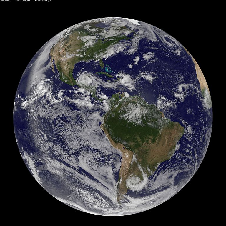
Image acquired August 8, 2012 There are three storms in the Atlantic Ocean basin on August 8, 2012 that have caught forecasters attention at the National Hurricane Center and they were captured in one image from NOAA's GOES-13 satellite. To the west lies Tropical Storm Ernesto, currently moving over Mexico. At 11:15 p.m. EDT on Tuesday, August 7, Belize radar indicated Ernesto made landfall along the southern Yucatan coast near Mahahual, Mexico as a category one hurricane with maximum sustained winds near 85 mph (140 kmh). At 10 a.m. EDT on August 8, Ernesto's maximum sustained winds were near 50 mph (85 kmh) and it was 265 miles (425 km) east of Coatzacoalcos, Mexico, near 18.7 North and 90.4 West. The National Hurricane Center expects Ernesto's center to emerge into the extreme southern Bay Of Campeche tonight where it is expected to re-strengthen. The second area forecasters are eyeing is that of post-tropical storm Florence's remains, located about 450 miles east of the Northern Leeward Islands. The remnants are still producing thunderstorms and showers, although it remains disorganized. The National Hurricane Center gives that low pressure area a "near zero" chance of becoming a tropical depression over the next couple of days. Farthest east lies a low pressure area associated with a tropical wave in the eastern Atlantic. It is about 700 miles west-southwest of the Cape Verde Islands and has a 30 percent chance of becoming a tropical depression in the next two days, according to the National Hurricane Center. Rob Gutro, NASA Goddard Space Flight Center NASA Goddard Space Flight Center enables NASA’s mission through four scientific endeavors: Earth Science, Heliophysics, Solar System Exploration, and Astrophysics. Goddard plays a leading role in NASA’s accomplishments by contributing compelling scientific knowledge to advance the Agency’s mission. Follow us on Twitter Like us on Facebook Find us on Instagram |
| Час створення | |
| Джерело | Satellite Sees An Atlantic Triple Tropical Threat |
| Автор | NASA Goddard Space Flight Center from Greenbelt, MD, USA |
Ліцензування
- Ви можете вільно:
- ділитися – копіювати, поширювати і передавати твір
- модифікувати – переробляти твір
- При дотриманні таких умов:
- зазначення авторства – Ви повинні вказати авторство, надати посилання на ліцензію і вказати, чи якісь зміни було внесено до оригінального твору. Ви можете зробити це в будь-який розсудливий спосіб, але так, щоб він жодним чином не натякав на те, наче ліцензіар підтримує Вас чи Ваш спосіб використання твору.
| Це зображення початково було завантажене користувачем NASA Goddard Photo and Video на Flickr за посиланням https://www.flickr.com/photos/24662369@N07/7741851934. 17 серпня 2012 його переглянув робот FlickreviewR і підтвердив, що зображення ліцензоване згідно з умовами cc-by-2.0. |
| Цей файл перебуває у суспільному надбанні, оскільки він був створений NASA (Національним управлінням з аеронавтики і дослідження космічного простору). Згідно з політикою NASA стосовно авторського права, «матеріали NASA не захищаються авторським правом, якщо не вказано протилежне». (Див. Template:PD-USGov, сторінку політики NASA стосовно авторського права, або політику використання зображень JPL.) | ||
 |
Попередження:
|
Історія файлу
Клацніть на дату/час, щоб переглянути, як тоді виглядав файл.
| Дата/час | Мініатюра | Розмір об'єкта | Користувач | Коментар | |
|---|---|---|---|---|---|
| поточний | 19:42, 17 серпня 2012 | | 3072 × 3072 (1,33 МБ) | Werieth | == {{int:filedesc}} == {{Information |Description=Image acquired August 8, 2012 There are three storms in the Atlantic Ocean basin on August 8, 2012 that have caught forecasters attention at the National Hurricane Center and they were captured in one ... |
Використання файлу
Такі сторінки використовують цей файл: