Файл:Constanta STS112-E-6329 lrg.jpg

Розмір при попередньому перегляді: 408 × 599 пікселів. Інші роздільності: 163 × 240 пікселів | 327 × 480 пікселів | 1000 × 1469 пікселів.
Повна роздільність (1000 × 1469 пікселів, розмір файлу: 1,84 МБ, MIME-тип: image/jpeg)
| Відомості про цей файл містяться на Вікісховищі — централізованому сховищі вільних файлів мультимедіа для використання у проектах Фонду Вікімедіа. |
Опис файлу
| Опис |
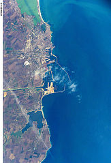
English: Constanța, Romania The modern city of Constanta, with a population of more than 348,000, is located on the western coast of the Black Sea and is the principal seaport for Romania. It is the site of the ancient Greek city of Tomis, colonized in the 6th century B.C. In the 1st century A.D. Tomis became a flourishing provincial capital of the Roman Empire when it acquired its current name from the emperor Constantine I. Today, Constanta is a thriving port-of-entry for Romania, offering both tourist attractions and an expanding, modern port facility that is among the largest on the Black Sea. The crew of STS-112 acquired this detailed digital image of the city on October 17, 2002, using a 400-mm lens. The older part of the city is situated near the large coastal lagoon to the north, while to the south the port facilities are connected to the Danube River’s import shipping commerce via the 64-km Danube – Black Sea Canal. Agricultural fields of mostly wheat and barley extend almost to the shorelines. |
| Час створення | |
| Джерело | http://visibleearth.nasa.gov/view.php?id=2961 |
| Автор | NASA |
| Місцеположення камери | | Перегляньте це та інші зображення поблизу на: OpenStreetMap |
|---|
Ліцензування
This file is in the public domain in the United States because it was created by the Image Science & Analysis Laboratory, of the NASA Johnson Space Center. NASA copyright policy states that "NASA material is not protected by copyright unless noted". (NASA media use guidelines or Conditions of Use of Astronaut Photographs).
Photo source: STS112-E-6329.
|
Історія файлу
Клацніть на дату/час, щоб переглянути, як тоді виглядав файл.
| Дата/час | Мініатюра | Розмір об'єкта | Користувач | Коментар | |
|---|---|---|---|---|---|
| поточний | 15:59, 2 травня 2013 | | 1000 × 1469 (1,84 МБ) | Calusarul | User created page with UploadWizard |
Використання файлу
Така сторінка використовує цей файл:
Глобальне використання файлу
Цей файл використовують такі інші вікі: