Файл:Babylon 1829 cropped.gif
Babylon_1829_cropped.gif (489 × 356 пікселів, розмір файлу: 75 КБ, MIME-тип: image/gif)
| Відомості про цей файл містяться на Вікісховищі — централізованому сховищі вільних файлів мультимедіа для використання у проектах Фонду Вікімедіа. |
| Опис |
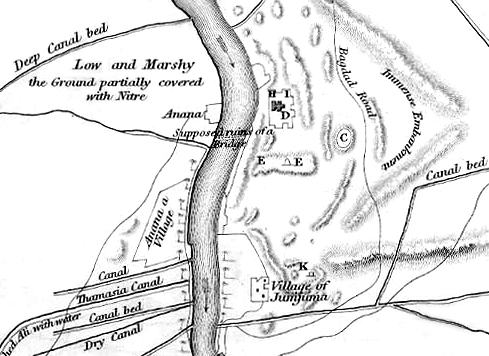
English: Map of the site of Babylon prior to its excavation later in the 19th century. |
| Час створення | (UTC) |
| Джерело |
|
| Автор |
|
| Це відредаговане зображення, тобто одержане цифровою обробкою з оригіналу. Зміни: Cropped to show southern area, highlighting the Jumjuma mound. Початкове зображення знаходиться тут: Babylon 1829.jpg. Відредагував ChrisO.
|
|
Ця робота перебуває у суспільному надбанні у країнах і територіях, де авторське право охороняється протягом життя автора та 70 років після того або менше.
| |
| Цей файл визнано вільним від відомих обмежень з боку закону про авторські права, включаючи всі пов'язані і суміжні права. | |
Журнал завантажень локального файлу
This image is a derivative work of the following images:
- File:Babylon_1829.jpg licensed with PD-old
- 2010-06-06T22:50:24Z ChrisO 1065x1464 (228517 Bytes) {{Information |Description={{en|1=Map of the site of Babylon prior to its excavation later in the 19th century.}} |Source=Ground Plan of the Remains at & near Babylon |Author=Captain R. Mignan |Date=October 1829 |Permission=
Uploaded with derivativeFX
Історія файлу
Клацніть на дату/час, щоб переглянути, як тоді виглядав файл.
| Дата/час | Мініатюра | Розмір об'єкта | Користувач | Коментар | |
|---|---|---|---|---|---|
| поточний | 20:56, 16 червня 2010 | | 489 × 356 (75 КБ) | ChrisO | |
| 23:07, 6 червня 2010 |  | 489 × 356 (88 КБ) | ChrisO | {{Information |Description={{en|1=Map of the site of Babylon prior to its excavation later in the 19th century.}} |Source=*File:Babylon_1829.jpg |Date=2010-06-06 23:07 (UTC) |Author=*File:Babylon_1829.jpg: Captain R. Mignan *derivative work: ~ |
Використання файлу
Такі сторінки використовують цей файл:
Глобальне використання файлу
Цей файл використовують такі інші вікі:
- Використання в ar.wikipedia.org
- Використання в bn.wikipedia.org
- Використання в en.wikipedia.org
- Використання в es.wikipedia.org
- Використання в fa.wikipedia.org
- Використання в fr.wikipedia.org
- Використання в he.wikipedia.org
- Використання в hyw.wikipedia.org
- Використання в no.wikipedia.org